File:Azimuthal equidistant projection centered on Kinshasa, 4⁰18ʹS., 15⁰18ʹE. 7-69. LOC 75692491.jpg

Size of this preview: 565 × 599 pixels. Other resolutions: 226 × 240 pixels | 453 × 480 pixels | 724 × 768 pixels | 966 × 1,024 pixels | 1,931 × 2,048 pixels | 11,516 × 12,213 pixels.
Original file (11,516 × 12,213 pixels, file size: 12.18 MB, MIME type: image/jpeg)
Captions
Captions
Add a one-line explanation of what this file represents
Summary
edit| Warning | The original file is very high-resolution. It might not load properly or could cause your browser to freeze when opened at full size. |
|---|
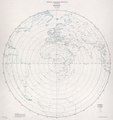
| Description |
English: Scale 1:32,000,000. Shows radial distances. "58341." Available also through the Library of Congress Web site as a raster image. AACR2 |
||
| Title | Azimuthal equidistant projection centered on Kinshasa, 4⁰18ʹS., 15⁰18ʹE. 7-69. | ||
| Shelf ID | G3201.B72 1969 .U5 | ||
| Date | |||
| Source | https://www.loc.gov/item/75692491/ | ||
| Author | United States. Central Intelligence Agency | ||
| Permission (Reusing this file) |
|
||
| Other versions |
|
||
| Location | Kinshasa · Earth · Congo | ||
| Part of | American Memory · General Maps · Catalog · Geography And Map Division | ||
| Subject | World Maps · Maps · Distances, Etc · Earth · Kinshasa (Congo) · Azimuthal Equidistant Projection (Cartography) |

Licensing
edit
| This image is a work of a Central Intelligence Agency employee, taken or made as part of that person's official duties. As a Work of the United States Government, this image or media is in the public domain in the United States.
|

|
File history
Click on a date/time to view the file as it appeared at that time.
| Date/Time | Thumbnail | Dimensions | User | Comment | |
|---|---|---|---|---|---|
| current | 02:07, 16 July 2018 | | 11,516 × 12,213 (12.18 MB) | Fæ (talk | contribs) | LOC Maps https://www.loc.gov/item/75692491/ #497 |
You cannot overwrite this file.
File usage on Commons
The following page uses this file: