File:Bacon's military map of the United States shewing the forts & fortifications. LOC 99447070.jpg

Size of this preview: 800 × 513 pixels. Other resolutions: 320 × 205 pixels | 640 × 410 pixels | 1,024 × 656 pixels | 1,280 × 820 pixels | 2,560 × 1,640 pixels | 8,141 × 5,216 pixels.
Original file (8,141 × 5,216 pixels, file size: 8.72 MB, MIME type: image/jpeg)
Captions
Captions
Add a one-line explanation of what this file represents
Summary
edit| Description |
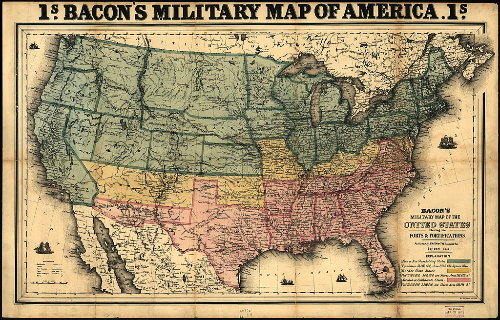
English: Scale ca. 1:8,000,000. LC Civil War Maps (2nd ed.), 24 Ent. Sta. Hall: Aug. 182 , 1862. At top of map: 1s. Bacon's military map of America. 1s. Forts are named and marked by small flags. Map also includes towns, railroads, names and boundaries of states and territories, and relief by hachures. "Free or non-slaveholding states" are colored green, "border slave states" are yellow, and "seceded or Confederate States" are pink. Description derived from published bibliography. Available also through the Library of Congress web site as raster image. |
||
| Title | Bacon's military map of the United States shewing the forts & fortifications. | ||
| Shelf ID | G3701.S5 1862 .B3 | ||
| Date | |||
| Source | https://www.loc.gov/item/99447070/ | ||
| Author | Bacon And Company | ||
| Permission (Reusing this file) |
|
||
| Other versions |
|
||
| Location | United States | ||
| Part of | Military Battles And Campaigns · American Memory · Civil War Maps · Catalog · Geography And Map Division | ||
| Subject | United States · Maps · Civil War · History |


Licensing
edit
|
This is a faithful photographic reproduction of a two-dimensional, public domain work of art. The work of art itself is in the public domain for the following reason:
The official position taken by the Wikimedia Foundation is that "faithful reproductions of two-dimensional public domain works of art are public domain".
This photographic reproduction is therefore also considered to be in the public domain in the United States. In other jurisdictions, re-use of this content may be restricted; see Reuse of PD-Art photographs for details. | ||||
File history
Click on a date/time to view the file as it appeared at that time.
| Date/Time | Thumbnail | Dimensions | User | Comment | |
|---|---|---|---|---|---|
| current | 21:46, 15 May 2018 | | 8,141 × 5,216 (8.72 MB) | Fæ (talk | contribs) | LOC Maps https://www.loc.gov/item/99447070/ #9173 |
You cannot overwrite this file.
File usage on Commons
The following page uses this file: