File:Battle of Hanover Court House, Virginia, May 26, 1862 LOC gvhs01.vhs00213.tif

Size of this JPG preview of this TIF file: 800 × 486 pixels. Other resolutions: 320 × 195 pixels | 640 × 389 pixels | 1,024 × 623 pixels | 1,280 × 778 pixels | 2,528 × 1,537 pixels.
Original file (2,528 × 1,537 pixels, file size: 11.12 MB, MIME type: image/tiff)
Captions
Captions
Add a one-line explanation of what this file represents
Summary
edit| Description |
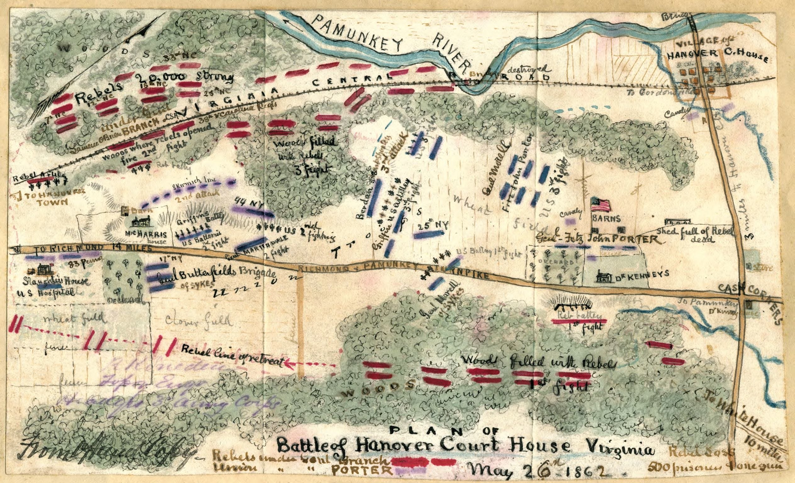
English: Shows the area around Hanover Court House, Va., sight of a skirmish between Union and Confederate forces as McClellan's advance up the Virginia Peninsula continued its slow pace. In this depiction, the Pamunkey River is located to the north, and the Richmond & Pamunkey Turnpike is also indicated. |
||
| Title | Battle of Hanover Court House, Virginia, May 26, 1862 | ||
| Shelf ID | https://www.loc.gov/item/001-CABIB20007329/ | ||
| Date | |||
| Source | https://www.loc.gov/item/gvhs01.vhs00213/ | ||
| Author | Sneden, Robert Knox | ||
| Permission (Reusing this file) |
|
||
| Other versions |
|
||
| Location | United States · Hanover County · Virginia · Hanover Court House | ||
| Part of | Military Battles And Campaigns · American Memory · Civil War Maps · Geography And Map Division | ||
| Subject | Hanover County · Hanover County (Va.) · Virginia · Civil War · United States · Maps · Peninsular Campaign · Hanover Court House (Va.) · Hanover Court House · History |


Licensing
edit|
This is a faithful photographic reproduction of a two-dimensional, public domain work of art. The work of art itself is in the public domain for the following reason:
The official position taken by the Wikimedia Foundation is that "faithful reproductions of two-dimensional public domain works of art are public domain".
This photographic reproduction is therefore also considered to be in the public domain in the United States. In other jurisdictions, re-use of this content may be restricted; see Reuse of PD-Art photographs for details. | ||||
File history
Click on a date/time to view the file as it appeared at that time.
| Date/Time | Thumbnail | Dimensions | User | Comment | |
|---|---|---|---|---|---|
| current | 13:37, 10 May 2018 |  | 2,528 × 1,537 (11.12 MB) | Fæ (talk | contribs) | LOC Maps https://www.loc.gov/item/gvhs01.vhs00213/ #95 |
You cannot overwrite this file.
File usage on Commons
The following page uses this file: