File:Bay of Naples ESA218751.tiff

Original file (5,000 × 5,010 pixels, file size: 69.84 MB, MIME type: image/tiff)
Captions
Captions
Summary edit
| DescriptionBay of Naples ESA218751.tiff |
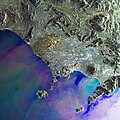
English: This Envisat Advanced Synthetic Aperture Radar (ASAR) composite image shows the Bay of Naples off the west coast of Italy. The bay is lined to the south by the Sorrento Peninsula – where the world-famous Amalfi coast runs along its southern edge. Just beyond the tip of the peninsula lies the beautiful island of Capri. The islands of Ischia, renowned for its thermal springs, and Procida can be seen to the top of the bay.
The image clearly displays the signs of volcanism in this region. Formed as a result of the collision between the African and Eurasian tectonic plates, Mount Vesuvius is featured just inland from the bay overlooking the city of Naples. This volcano has erupted many times, most notably in 79 AD when the cataclysmic eruption buried the surrounding area with up to 30 m of ash. The towns of Pompeii and Herculaneum were excavated last century, providing a snapshot of what Roman life was like almost 2000 years ago. The region around this volcano is home to more than three million people and with the last eruption occurring in 1944, it is intensively monitored for signs of unrest. Further signs of volcanism can be seen at the western end of the bay where the Phlegraean Fields lie. This complex structure, most of which is below sea level, is constantly on the move due to subsidence and uplift. This image was created by combining three Envisat ASAR acquisitions taken over the same area. The colours in the image result from variations on the surface that occurred between acquisitions. |
| Date | |
| Source | http://www.esa.int/spaceinimages/Images/2010/03/Bay_of_Naples |
| Author | European Space Agency |
| Permission (Reusing this file) |
ESA,CC BY-SA 3.0 IGO |
| Other versions |
|
| Title InfoField | Bay of Naples |
| Set InfoField | Earth observation image of the week |
| System InfoField | Envisat ASAR |
| Mission InfoField | Envisat |
| Location InfoField | Italy |
| Activity InfoField | Observing the Earth |
| Keywords InfoField | Land use; Oceans and coastal zones |
Licensing edit
- You are free:
- to share – to copy, distribute and transmit the work
- to remix – to adapt the work
- Under the following conditions:
- attribution – You must give appropriate credit, provide a link to the license, and indicate if changes were made. You may do so in any reasonable manner, but not in any way that suggests the licensor endorses you or your use.
- share alike – If you remix, transform, or build upon the material, you must distribute your contributions under the same or compatible license as the original.

File history
Click on a date/time to view the file as it appeared at that time.
| Date/Time | Thumbnail | Dimensions | User | Comment | |
|---|---|---|---|---|---|
| current | 15:19, 24 May 2017 |  | 5,000 × 5,010 (69.84 MB) | Fæ (talk | contribs) | European Space Agency, Id 218751, http://www.esa.int/spaceinimages/Images/2010/03/Bay_of_Naples, User:Fæ/Project_list/ESA |
You cannot overwrite this file.
File usage on Commons
The following page uses this file:
Metadata
This file contains additional information such as Exif metadata which may have been added by the digital camera, scanner, or software program used to create or digitize it. If the file has been modified from its original state, some details such as the timestamp may not fully reflect those of the original file. The timestamp is only as accurate as the clock in the camera, and it may be completely wrong.
| height | 5,010 |
|---|---|
| width | 5,000 |
| Width | 5,000 px |
| Height | 5,010 px |
| Bits per component |
|
| Compression scheme | LZW |
| Pixel composition | RGB |
| Orientation | Normal |
| Number of components | 3 |
| Number of rows per strip | 17 |
| Horizontal resolution | 72 dpi |
| Vertical resolution | 72 dpi |
| Data arrangement | chunky format |
| Software used | Adobe Photoshop CS4 Windows |
| File change date and time | 14:16, 29 March 2010 |
| Color space | Uncalibrated |
