File:Beverly Presbyterian Church in the town of Beverly, one of the first settlements west of the Allegheny Mountains, founded in 1790 in the Tygart River Valley of what was then Virginia and is now (in LCCN2015634443.tif

Size of this JPG preview of this TIF file: 539 × 599 pixels. Other resolutions: 216 × 240 pixels | 432 × 480 pixels | 691 × 768 pixels | 921 × 1,024 pixels | 1,842 × 2,048 pixels | 5,792 × 6,438 pixels.
Original file (5,792 × 6,438 pixels, file size: 213.41 MB, MIME type: image/tiff)
Captions
Captions
Add a one-line explanation of what this file represents
Summary edit
| Description |
English: Title: Beverly Presbyterian Church in the town of Beverly, one of the first settlements west of the Allegheny Mountains, founded in 1790 in the Tygart River Valley of what was then Virginia and is now (in 2015) West Virginia
Physical description: 1 photograph : digital, tiff file, color. Notes: Purchase; Carol M. Highsmith Photography, Inc.; 2015; (DLC/PP-2015:055).; Credit line: West Virginia Collection within the Carol M. Highsmith Archive, Library of Congress, Prints and Photographs Division.; Forms part of: West Virginia Collection within the Carol M. Highsmith Archive.; Title, date and keywords based on information provided by the photographer. |
||||||||||||||||||||||||||
| Date | Taken on 26 October 2015, 10:53 (according to Exif data) | ||||||||||||||||||||||||||
| Source |
Library of Congress
|
||||||||||||||||||||||||||
| Author |
|
||||||||||||||||||||||||||
| Permission (Reusing this file) |
No known restrictions on publication.
|
||||||||||||||||||||||||||


| Camera location | | View this and other nearby images on: OpenStreetMap |
|---|
Licensing edit
| This work is from the Carol M. Highsmith Archive collection at the Library of Congress. According to the library, there are no known copyright restrictions on the use of this work. Carol M. Highsmith has stipulated that her photographs are in the public domain. Photographs of sculpture or other works of art may be restricted by the copyright of the artist. |
 |
File history
Click on a date/time to view the file as it appeared at that time.
| Date/Time | Thumbnail | Dimensions | User | Comment | |
|---|---|---|---|---|---|
| current | 09:23, 19 September 2016 |  | 5,792 × 6,438 (213.41 MB) | Fæ (talk | contribs) | LOC 2015634443, Carol M. Highsmith collection. P619.15360 TIFF (213.4mb) |
| 09:22, 19 September 2016 | 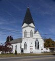 | 5,792 × 6,438 (213.41 MB) | Fæ (talk | contribs) | LOC 2015634443, Carol M. Highsmith collection. P619.15360 TIFF (213.4mb) |
You cannot overwrite this file.
File usage on Commons
There are no pages that use this file.