File:Bienville National Forest, Mississippi - 1983 LOC 2001628514.tif

Size of this JPG preview of this TIF file: 456 × 600 pixels. Other resolutions: 182 × 240 pixels | 365 × 480 pixels | 584 × 768 pixels | 779 × 1,024 pixels | 1,557 × 2,048 pixels | 6,054 × 7,960 pixels.
Original file (6,054 × 7,960 pixels, file size: 137.87 MB, MIME type: image/tiff)
Captions
Captions
Add a one-line explanation of what this file represents
Summary edit
| Description |
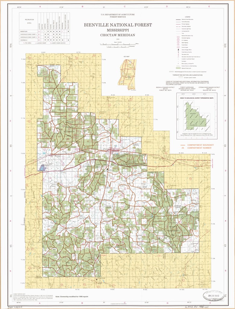
English: "Note: Ownership modified for 1998 reprint." Relief shown by spot heights. "Forest Service map." "Land status current as of December 1983." "Choctaw meridian." Includes table of recreation sites, location map, and index map. Compartment boundaries and numbers added to general map in brown. Available also through the Library of Congress Web site as a raster image. |
||
| Title | Bienville National Forest, Mississippi : 1983 | ||
| Shelf ID | G3982.B5 1998 .U5 | ||
| Date | |||
| Source | https://www.loc.gov/item/2001628514/ | ||
| Author | United States. Forest Service. Southern Region; Geometronics Service Center (U.S.) | ||
| Permission (Reusing this file) |
|
||
| Other versions |
|
||
| Location | United States · Bienville National Forest. · Mississippi · Bienville National Forest | ||
| Part of | American Memory · General Maps · Catalog · Geography And Map Division | ||
| Subject | United States · Maps · Mississippi · Bienville National Forest (Miss.) · Bienville National Forest |


Licensing edit
| This work is from the Library of Congress. According to the library, there are no known copyright restrictions on the use of this work. |  |
File history
Click on a date/time to view the file as it appeared at that time.
| Date/Time | Thumbnail | Dimensions | User | Comment | |
|---|---|---|---|---|---|
| current | 03:36, 7 February 2019 |  | 6,054 × 7,960 (137.87 MB) | Fæ (talk | contribs) | LOC Maps https://www.loc.gov/item/2001628514/ #5834 |
You cannot overwrite this file.
File usage on Commons
The following page uses this file:
File usage on other wikis
The following other wikis use this file:
- Usage on en.wikipedia.org