File:Birds eye view of Mount Sterling, Brown County, Illinois 1869. LOC 73693365.jpg

Size of this preview: 770 × 599 pixels. Other resolutions: 309 × 240 pixels | 617 × 480 pixels | 987 × 768 pixels | 1,280 × 996 pixels | 2,560 × 1,992 pixels | 6,928 × 5,392 pixels.
Original file (6,928 × 5,392 pixels, file size: 6.48 MB, MIME type: image/jpeg)
Captions
Captions
Add a one-line explanation of what this file represents
Summary edit
| Description |
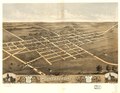
English: Perspective map not drawn to scale. LC Panoramic maps (2nd ed.), 172 Available also through the Library of Congress Web site as a raster image. Includes ill. and index to points of interest. Vault AACR2: 100; 710/1 |
||
| Title | Birds eye view of Mount Sterling, Brown County, Illinois 1869. | ||
| Shelf ID | G4104.M88A3 1869 .R8 | ||
| Date | |||
| Source | https://www.loc.gov/item/73693365/ | ||
| Author | Ruger, A.; Chicago Lithographing Co. | ||
| Permission (Reusing this file) |
|
||
| Other versions |
|
||
| Location | United States · Mount Sterling · Illinois | ||
| Part of | American Memory · Cities And Towns · Catalog · Panoramic Maps · Geography And Map Division | ||
| Subject | Mount Sterling (Ill.) · United States · Mount Sterling · Aerial Views · Illinois |

Licensing edit
|
This is a faithful photographic reproduction of a two-dimensional, public domain work of art. The work of art itself is in the public domain for the following reason:
The official position taken by the Wikimedia Foundation is that "faithful reproductions of two-dimensional public domain works of art are public domain".
This photographic reproduction is therefore also considered to be in the public domain in the United States. In other jurisdictions, re-use of this content may be restricted; see Reuse of PD-Art photographs for details. | ||||
File history
Click on a date/time to view the file as it appeared at that time.
| Date/Time | Thumbnail | Dimensions | User | Comment | |
|---|---|---|---|---|---|
| current | 02:48, 17 July 2018 | | 6,928 × 5,392 (6.48 MB) | Fæ (talk | contribs) | LOC Maps https://www.loc.gov/item/73693365/ #1886 |
You cannot overwrite this file.
File usage on Commons
The following page uses this file: