File:Bosnia and Herzegovina-ethnic population by opština, 1991 census. LOC 2009584225.jpg
Size of this preview: 636 × 600 pixels. Other resolutions: 255 × 240 pixels | 509 × 480 pixels | 814 × 768 pixels | 1,086 × 1,024 pixels | 2,172 × 2,048 pixels | 6,342 × 5,981 pixels.
Original file (6,342 × 5,981 pixels, file size: 5.79 MB, MIME type: image/jpeg)
Captions
Captions
Add a one-line explanation of what this file represents
Summary edit
| Description |
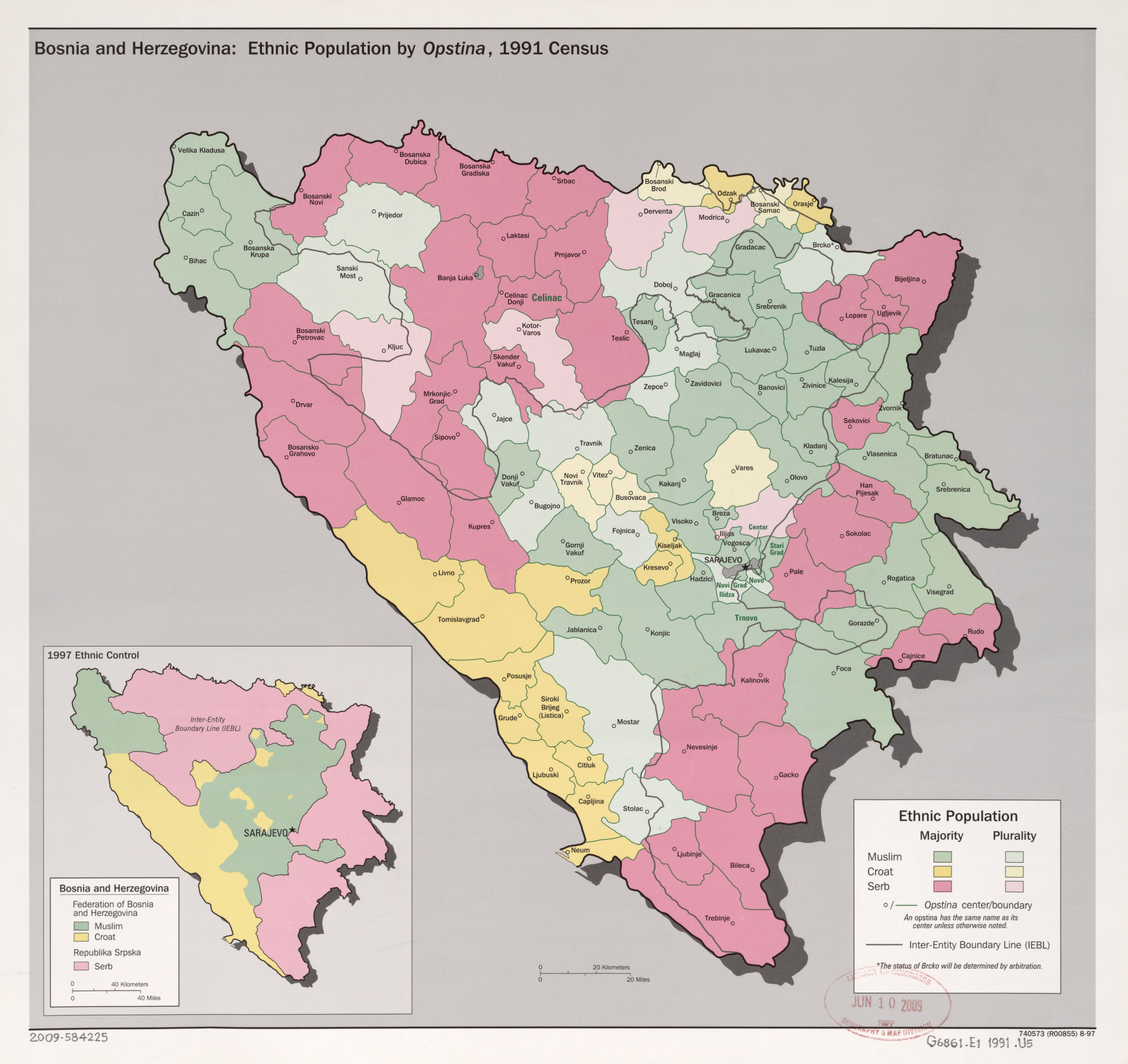
English: Also shows opština (commune) boundaries/administrative centers and inter-entity boundaries. "740573 (R00855) 8-97." Includes notes and inset of "1997 ethnic control". Available also through the Library of Congress Web site as a raster image. |
||
| Title | Bosnia and Herzegovina--ethnic population by opština, 1991 census. | ||
| Shelf ID | G6861.E1 1991 .U5 | ||
| Date | |||
| Source | https://www.loc.gov/item/2009584225/ | ||
| Author | United States. Central Intelligence Agency | ||
| Permission (Reusing this file) |
|
||
| Other versions |
|
||
| Location | Herzegovina · Bosnia And Herzegovina · Bosnia | ||
| Part of | American Memory · General Maps · Catalog · Geography And Map Division | ||
| Subject | Ethnology · Partition · Maps · Bosnia And Herzegovina · Administrative And Political Divisions · History |


Licensing edit
| This image is a work of a Central Intelligence Agency employee, taken or made as part of that person's official duties. As a Work of the United States Government, this image or media is in the public domain in the United States.
|

|
File history
Click on a date/time to view the file as it appeared at that time.
| Date/Time | Thumbnail | Dimensions | User | Comment | |
|---|---|---|---|---|---|
| current | 00:53, 10 May 2018 | | 6,342 × 5,981 (5.79 MB) | Fæ (talk | contribs) | LOC Maps https://www.loc.gov/item/2009584225/ #5104 |
You cannot overwrite this file.
File usage on Commons
The following page uses this file:
File usage on other wikis
The following other wikis use this file:
- Usage on it.wikipedia.org