File:Bundesarchiv Bild 183-Z0908-004, Dresden, Coschütz, Brauerei.jpg
Size of this preview: 414 × 600 pixels. Other resolutions: 165 × 240 pixels | 548 × 794 pixels.
Original file (548 × 794 pixels, file size: 62 KB, MIME type: image/jpeg)
Captions
Captions
Add a one-line explanation of what this file represents
Summary
edit| Photographer |
|
||||||||||||||||||||||||||
| Original caption |
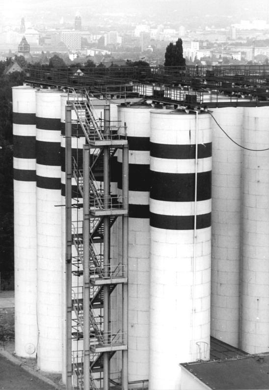
For documentary purposes the German Federal Archive often retained the original image captions, which may be erroneous, biased, obsolete or politically extreme. Dresden, Coschütz, Brauerei
ADN-ZB Häßler 8.9.81 Dresden: Die 22m hohen Reaktorentürme gehören zur neu erbauten Brauerei in Dresden-Coschütz, in der seit einigen Tagen "Vollbier Hell" und "Deutsches Pilsner" gezapft wird. Der Betrieb nimmt eine Fläche von rund 16 Hektar ein und wird bis 1983 schrittweise seine volle Kapazität von 1,3 Millionen Hektoliter pro Jahr erreichen. (siehe 3N) |
||||||||||||||||||||||||||
| Depicted place | Dresden | ||||||||||||||||||||||||||
| Date | 8 September 1981 | ||||||||||||||||||||||||||
| Collection |
|
||||||||||||||||||||||||||
| Current location |
Allgemeiner Deutscher Nachrichtendienst - Zentralbild (Bild 183) |
||||||||||||||||||||||||||
| Accession number | |||||||||||||||||||||||||||
| Source |
|
||||||||||||||||||||||||||

Licensing
edit
This file is licensed under the Creative Commons Attribution-Share Alike 3.0 Germany license.
Attribution: Bundesarchiv, Bild 183-Z0908-004 / CC-BY-SA 3.0
- You are free:
- to share – to copy, distribute and transmit the work
- to remix – to adapt the work
- Under the following conditions:
- attribution – You must give appropriate credit, provide a link to the license, and indicate if changes were made. You may do so in any reasonable manner, but not in any way that suggests the licensor endorses you or your use.
- share alike – If you remix, transform, or build upon the material, you must distribute your contributions under the same or compatible license as the original.

| Camera location | | View this and other nearby images on: OpenStreetMap |
|---|
| Object location | | View this and other nearby images on: OpenStreetMap |
|---|
File history
Click on a date/time to view the file as it appeared at that time.
| Date/Time | Thumbnail | Dimensions | User | Comment | |
|---|---|---|---|---|---|
| current | 11:46, 12 May 2016 | | 548 × 794 (62 KB) | Kopiersperre (talk | contribs) | next try |
| 11:45, 12 May 2016 |  | 580 × 800 (66 KB) | Kopiersperre (talk | contribs) | cropped | |
| 18:46, 4 December 2008 |  | 580 × 800 (66 KB) | BArchBot (talk | contribs) | == Summary == {{Information |Description={{BArch-description|1='''Dresden, Coschütz, Brauerei''' ADN-ZB Häßler 8.9.81 Dresden: Die 22m hohen Reaktorentürme gehören zur neuerbauten Brauerei in Dresden-Coschütz, in der seit einigen Tagen "Vollbier H |
You cannot overwrite this file.
File usage on Commons
The following 2 pages use this file:
File usage on other wikis
The following other wikis use this file:
- Usage on de.wikipedia.org