File:Carte des Isles Lucayes. LOC 73697232.jpg
Size of this preview: 694 × 599 pixels. Other resolutions: 278 × 240 pixels | 556 × 480 pixels | 890 × 768 pixels | 1,186 × 1,024 pixels | 2,372 × 2,048 pixels | 4,656 × 4,020 pixels.
Original file (4,656 × 4,020 pixels, file size: 2.3 MB, MIME type: image/jpeg)
Captions
Captions
Add a one-line explanation of what this file represents
Summary
edit| Description |
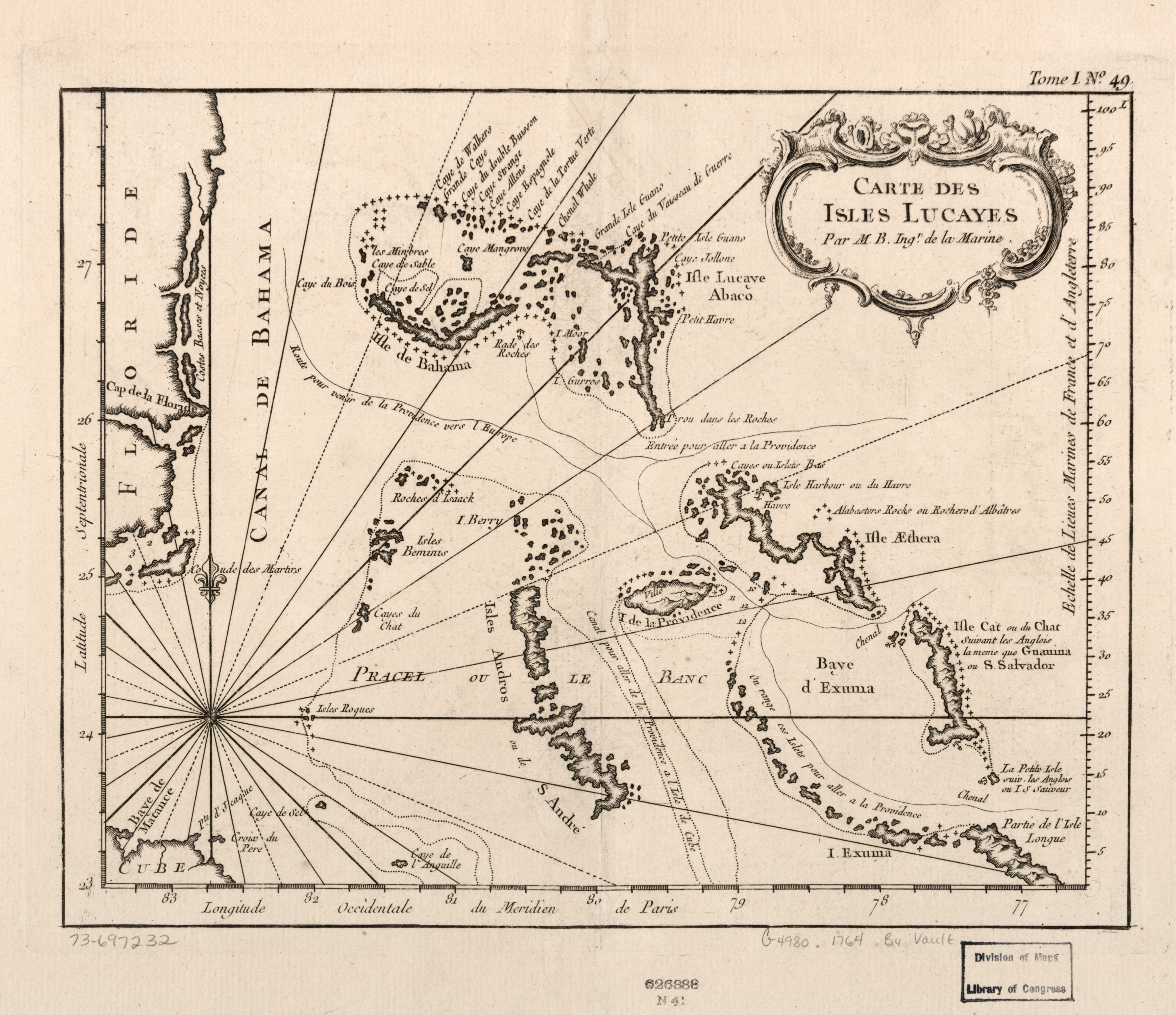
English: Scale ca. 1:2,800,000. LC Maps of North America, 1750-1789, 1749 Relief shown pictorially. Depths shown in fathoms. Shows ship channels and anchorages. Available also through the Library of Congress Web site as a raster image. "Tome I, no. 49." From the author's Le petit atlas maritime. 1764. Vault AACR2 |
||
| Title | Carte des Isles Lucayes. | ||
| Shelf ID | G4980 1764 .B4 | ||
| Date | |||
| Source | https://www.loc.gov/item/73697232/ | ||
| Author | Bellin, Jacques Nicolas | ||
| Permission (Reusing this file) |
|
||
| Other versions |
|
||
| Location | Bahamas | ||
| Part of | Military Battles And Campaigns · American Memory · Catalog · Geography And Map Division · American Revolution And Its Era: Maps And Charts Of North America And The West Indies, 1750-1789 | ||
| Subject | Bahamas · Maps · Early Works To 1800 · Early Maps |


Licensing
edit
|
This is a faithful photographic reproduction of a two-dimensional, public domain work of art. The work of art itself is in the public domain for the following reason:
The official position taken by the Wikimedia Foundation is that "faithful reproductions of two-dimensional public domain works of art are public domain".
This photographic reproduction is therefore also considered to be in the public domain in the United States. In other jurisdictions, re-use of this content may be restricted; see Reuse of PD-Art photographs for details. | ||||
File history
Click on a date/time to view the file as it appeared at that time.
| Date/Time | Thumbnail | Dimensions | User | Comment | |
|---|---|---|---|---|---|
| current | 21:57, 25 May 2018 | | 4,656 × 4,020 (2.3 MB) | Fæ (talk | contribs) | LOC Maps https://www.loc.gov/item/73697232/ #1261 |
You cannot overwrite this file.
File usage on Commons
The following page uses this file: