File:Carte des pays connus sous le nom de Canada, dans laquelle sont distinguées les possessions françoises, & angl? LOC 73695756.tif

Size of this JPG preview of this TIF file: 729 × 600 pixels. Other resolutions: 292 × 240 pixels | 584 × 480 pixels | 934 × 768 pixels | 1,245 × 1,024 pixels | 2,490 × 2,048 pixels | 8,140 × 6,696 pixels.
Original file (8,140 × 6,696 pixels, file size: 155.94 MB, MIME type: image/tiff)
Captions
Captions
Add a one-line explanation of what this file represents
Summary
edit| Description |
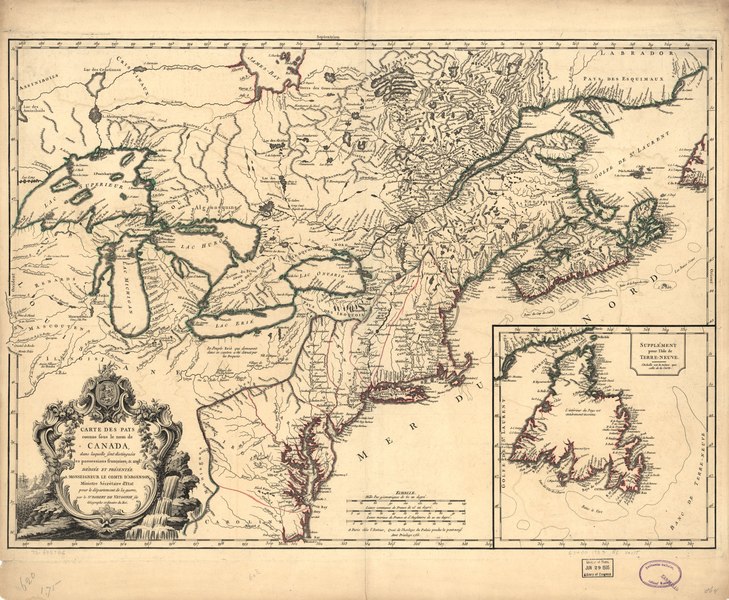
English: Scale ca. 1:4,000,000. Hand colored. Relief shown pictorially. Shows British colonies as far south as the present state of North Carolina. Includes "Supplément pour l'isle de Terre-Neuve." LC Maps of North America, 1750-1789, 15 Available also through the Library of Congress Web site as a raster image. Vault AACR2 |
||
| Title | Carte des pays connus sous le nom de Canada, dans laquelle sont distinguées les possessions françoises, & angl? | ||
| Shelf ID | G3400 1753 .R6 | ||
| Date | |||
| Source | https://www.loc.gov/item/73695756/ | ||
| Author | Robert De Vaugondy, Didier | ||
| Permission (Reusing this file) |
|
||
| Other versions |
|
||
| Location | Canada · United States · New France | ||
| Part of | Military Battles And Campaigns · American Memory · Catalog · Geography And Map Division · American Revolution And Its Era: Maps And Charts Of North America And The West Indies, 1750-1789 | ||
| Subject | Canada · Maps · Early Works To 1800 · New France · United States |


Licensing
edit|
This is a faithful photographic reproduction of a two-dimensional, public domain work of art. The work of art itself is in the public domain for the following reason:
The official position taken by the Wikimedia Foundation is that "faithful reproductions of two-dimensional public domain works of art are public domain".
This photographic reproduction is therefore also considered to be in the public domain in the United States. In other jurisdictions, re-use of this content may be restricted; see Reuse of PD-Art photographs for details. | ||||
File history
Click on a date/time to view the file as it appeared at that time.
| Date/Time | Thumbnail | Dimensions | User | Comment | |
|---|---|---|---|---|---|
| current | 14:13, 2 June 2018 |  | 8,140 × 6,696 (155.94 MB) | Fæ (talk | contribs) | LOC Maps https://www.loc.gov/item/73695756/ #17992 |
You cannot overwrite this file.
File usage on Commons
The following page uses this file: