File:Carte nouvelle de l'Amérique angloise contenant tout ce que les Anglois possédent sur le continent de l'Amérique septentrionale savoir le Canada, la Nouvelle Ecosse ou Acadie, les treize provinces LOC 74692109.jpg

Size of this preview: 482 × 599 pixels. Other resolutions: 193 × 240 pixels | 386 × 480 pixels | 618 × 768 pixels | 823 × 1,024 pixels | 1,647 × 2,048 pixels | 6,091 × 7,574 pixels.
Original file (6,091 × 7,574 pixels, file size: 8.07 MB, MIME type: image/jpeg)
Captions
Captions
Add a one-line explanation of what this file represents
Summary edit
| Description |
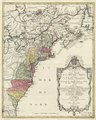
English: Scale ca. 1:3,500,000. Hand colored. Relief shown pictorially. Appears in Tobias Conrad Lotter's Atlas géographique. 1778. Available also through the Library of Congress Web site as a raster image. Two copies. Copy 1, borders of some smaller lakes colored. Copy 2, borders of smaller lakes uncolored. Vault AACR2 |
||
| Title | Carte nouvelle de l'Amérique angloise contenant tout ce que les Anglois possédent sur le continent de l'Amérique septentrionale savoir le Canada, la Nouvelle Ecosse ou Acadie, les treize provinces unies qui font: les quatres colonies de la Nouvelle Angleterre ... | ||
| Shelf ID | G3300 1776 .L6 | ||
| Date | |||
| Source | https://www.loc.gov/item/74692109/ | ||
| Author | Lotter, Matthäus Albrecht | ||
| Permission (Reusing this file) |
|
||
| Other versions |
|
||
| Location | North America · United States · America | ||
| Part of | Military Battles And Campaigns · American Memory · Catalog · Geography And Map Division · American Revolution And Its Era: Maps And Charts Of North America And The West Indies, 1750-1789 | ||
| Subject | United States · British · North America · Maps · Early Works To 1800 · America |

Licensing edit
|
This is a faithful photographic reproduction of a two-dimensional, public domain work of art. The work of art itself is in the public domain for the following reason:
The official position taken by the Wikimedia Foundation is that "faithful reproductions of two-dimensional public domain works of art are public domain".
This photographic reproduction is therefore also considered to be in the public domain in the United States. In other jurisdictions, re-use of this content may be restricted; see Reuse of PD-Art photographs for details. | ||||
File history
Click on a date/time to view the file as it appeared at that time.
| Date/Time | Thumbnail | Dimensions | User | Comment | |
|---|---|---|---|---|---|
| current | 21:44, 25 May 2018 | | 6,091 × 7,574 (8.07 MB) | Fæ (talk | contribs) | LOC Maps https://www.loc.gov/item/74692109/ #1246 |
You cannot overwrite this file.
File usage on Commons
The following page uses this file: