File:Carte reduite des mers comprises entre l'Asie et l'Amerique - apelées par les navigateurs Mer du Sud ou Mer pacifique - pour servir aux vaisseaux du Roi - dressée aux dépost des cartes, plans et NYPL465027.tiff

Size of this PNG preview of this TIF file: 800 × 544 pixels. Other resolutions: 320 × 218 pixels | 640 × 436 pixels | 1,024 × 697 pixels | 1,280 × 871 pixels | 2,560 × 1,742 pixels | 5,355 × 3,644 pixels.
Original file (5,355 × 3,644 pixels, file size: 39.3 MB, MIME type: image/tiff)
Captions
Captions
Add a one-line explanation of what this file represents
Summary edit
| Description |
Français : Carte reduite des mers comprises entre l'Asie et l'Amerique; apelées par les navigateurs Mer du Sud ou Mer pacifique; pour servir aux vaisseaux du Roi / dressée aux dépost des cartes, plans et journaux de la marine, par ordre de M. le Comte de Maurepas, 1742; Dheulland, sculp.
English: Maps of the Oceans / Pacific Ocean |
|||||||||||||||||||||||
| Notes | Cette carte a eth corrighe en 1756. ''Note 2.'') Covers eastern North America as far north as Delaware Bay. ''Note 3.'') Ford Collection. ''Note 4.'') National Endowment for the Humanities Grant for Access to Early Maps of the Middle Atlantic Seaboard. ''Note 5.'') Prime meridians: Paris, Cap Lezard, London, Teneriffe, and Ferro. ''Note 6.'') Relief shown pictorially. ''Note 7.'') Title within ornamental cartouche. | |||||||||||||||||||||||
| Item physical description | 1 map; hand col.; 54 x 83 cm. | |||||||||||||||||||||||
| Catalogue call number | Map Div. 02-323 | |||||||||||||||||||||||
| Date | ||||||||||||||||||||||||
| Source |
http://digitalgallery.nypl.org/nypldigital/dgkeysearchdetail.cfm?imageID=465027
|
|||||||||||||||||||||||
| Author | Guillaume d', d. ca. 1770 - Engraver Heulland | |||||||||||||||||||||||
| Permission (Reusing this file) |
From The Lionel Pincus and Princess Firyal Map Division. http://maps.nypl.org
|
|||||||||||||||||||||||
| Location | Stephen A. Schwarzman Building / The Lionel Pincus and Princess Firyal Map Division | |||||||||||||||||||||||
| Digital item published | 2-3-2004; updated 3-25-2011 | |||||||||||||||||||||||
| Digital ID | 465027 | |||||||||||||||||||||||

The making of this file was supported by Wikimedia UK.
To see other files made with the support of Wikimedia UK, please see the category Supported by Wikimedia UK.
|
File history
Click on a date/time to view the file as it appeared at that time.
| Date/Time | Thumbnail | Dimensions | User | Comment | |
|---|---|---|---|---|---|
| current | 10:43, 25 September 2022 | 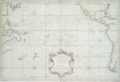 | 5,355 × 3,644 (39.3 MB) | Enyavar (talk | contribs) | Cropped 7 % horizontally, 14 % vertically, rotated 0.6° using CropTool with precise mode. |
| 17:01, 12 August 2015 |  | 5,771 × 4,256 (46.13 MB) | Finavon (talk | contribs) | rotated | |
| 08:22, 6 May 2014 |  | 4,256 × 5,771 (70.28 MB) | Fæ (talk | contribs) | GWToolset: Creating mediafile for Fæ. Tranche 3 3501-5495 (repairs) @ 4 May 2014, 10:46 BST |
You cannot overwrite this file.
File usage on Commons
The following page uses this file:
File usage on other wikis
The following other wikis use this file:
- Usage on fr.wikipedia.org