File:Chamizal National Memorial, Texas, official map and guide LOC 2014590026.tif
Size of this JPG preview of this TIF file: 800 × 586 pixels. Other resolutions: 320 × 235 pixels | 640 × 469 pixels | 1,024 × 750 pixels | 1,280 × 938 pixels | 2,560 × 1,876 pixels | 7,277 × 5,333 pixels.
Original file (7,277 × 5,333 pixels, file size: 111.03 MB, MIME type: image/tiff)
Captions
Captions
Add a one-line explanation of what this file represents
Summary edit
| Description |
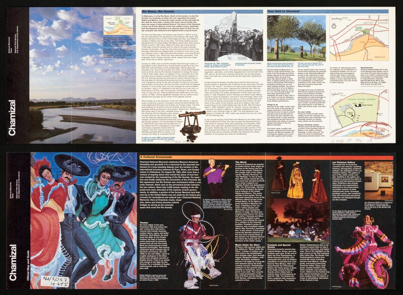
English: Title from panel. "*GPO:1996--404-952/40185." Includes text, area map, diagram showing the Rio Grande's channel, and illustrations (some color). Text and color illustrations on verso. Available also through the Library of Congress Web site as a raster image. |
||
| Title | Chamizal National Memorial, Texas, official map and guide | ||
| Shelf ID | G4032.C5 1996 .U5 | ||
| Date | |||
| Source | https://www.loc.gov/item/2014590026/ | ||
| Author | United States. National Park Service | ||
| Permission (Reusing this file) |
|
||
| Other versions |
|
||
| Location | United States · El Paso · Chamizal National Memorial (El Paso) · Texas · Chamizal National Memorial | ||
| Part of | American Memory · General Maps · Catalog · Geography And Map Division | ||
| Subject | United States · Chamizal National Memorial (El Paso, Tex.) · Chamizal National Memorial (El Paso) · Texas · Maps |


Licensing edit
| This image or media file contains material based on a work of a National Park Service employee, created as part of that person's official duties. As a work of the U.S. federal government, such work is in the public domain in the United States. See the NPS website and NPS copyright policy for more information. |
File history
Click on a date/time to view the file as it appeared at that time.
| Date/Time | Thumbnail | Dimensions | User | Comment | |
|---|---|---|---|---|---|
| current | 23:45, 21 January 2020 |  | 7,277 × 5,333 (111.03 MB) | Fæ (talk | contribs) | LOC Maps https://www.loc.gov/item/2014590026/ #29233 |
You cannot overwrite this file.
File usage on Commons
The following page uses this file: