File:Chart and plan of the harbour of New York & the couny. adjacent, from Sandy Hook to Kingsbridge - comprehending the whole of New York and Staten Islands, and part of Long Island & the Jersey shore, NYPL1254024.tiff

Size of this JPG preview of this TIF file: 407 × 599 pixels. Other resolutions: 163 × 240 pixels | 326 × 480 pixels | 522 × 768 pixels | 696 × 1,024 pixels | 1,392 × 2,048 pixels | 3,289 × 4,840 pixels.
Original file (3,289 × 4,840 pixels, file size: 45.55 MB, MIME type: image/tiff)
Captions
Captions
Add a one-line explanation of what this file represents
Summary
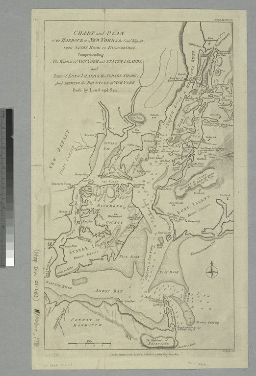
edit| Description | Chart and plan of the harbour of New York & the couny. adjacent, from Sandy Hook to Kingsbridge : comprehending the whole of New York and Staten Islands, and part of Long Island & the Jersey shore, and shewing the defences of New York both by land and sea / Jno. Lodge, sculp. | |||||||||||||||||||||||
| Notes | Relief shown by hachures. Depths shown by soundings. Note 2.) In upper right corner: Political Mage. Novr. 1781. | |||||||||||||||||||||||
| Standard reference | Haskell, D.C. Manhattan maps, 534; Phillips. Maps of America, p. 528 | |||||||||||||||||||||||
| Physical description | 1 map : hand col. ; 42 x 25 cm. | |||||||||||||||||||||||
| Catalog Call Number | Map Div. 01-1763 [Filed with N.Y. Harbor, 1781] | |||||||||||||||||||||||
| Date | ||||||||||||||||||||||||
| Source |
http://digitalgallery.nypl.org/nypldigital/dgkeysearchdetail.cfm?imageID=1254024
|
|||||||||||||||||||||||
| Author | Lodge, John, d. 1796 -- EngraverBew, John, d. 1793 -- Publisher | |||||||||||||||||||||||
| Permission (Reusing this file) |
From The Lionel Pincus & Princess Firyal Map Division. Released on a CC0 license.[1] | |||||||||||||||||||||||
| Digital ID | 1254024 | |||||||||||||||||||||||
| Location | Stephen A. Schwarzman Building / The Lionel Pincus and Princess Firyal Map Division | |||||||||||||||||||||||
| NYPL digital item published | 2-28-2005; updated 3-25-2011 | |||||||||||||||||||||||

Licensing
edit| This file is made available under the Creative Commons CC0 1.0 Universal Public Domain Dedication. | |
| The person who associated a work with this deed has dedicated the work to the public domain by waiving all of their rights to the work worldwide under copyright law, including all related and neighboring rights, to the extent allowed by law. You can copy, modify, distribute and perform the work, even for commercial purposes, all without asking permission.
|
The making of this file was supported by Wikimedia UK.
To see other files made with the support of Wikimedia UK, please see the category Supported by Wikimedia UK.
|
File history
Click on a date/time to view the file as it appeared at that time.
| Date/Time | Thumbnail | Dimensions | User | Comment | |
|---|---|---|---|---|---|
| current | 20:46, 18 April 2014 |  | 3,289 × 4,840 (45.55 MB) | Fæ (talk | contribs) | =={{int:filedesc}}== {{NYPL_map |digital_id = 1254024 |standard_reference = Haskell, D.C. Manhattan maps, 534; Phillips. Maps of America, p. 528 |record_id = 607349 |catalog_call_number = Map Div. 01-1763 [Filed with N.Y. Harbor, 1781] |creator = Lodge... |
You cannot overwrite this file.
File usage on Commons
There are no pages that use this file.