File:Chart of the coast of Georgia RMG K0407.jpg
Size of this preview: 450 × 599 pixels. Other resolutions: 180 × 240 pixels | 361 × 480 pixels | 962 × 1,280 pixels.
Original file (962 × 1,280 pixels, file size: 995 KB, MIME type: image/jpeg)
Captions
Captions
Add a one-line explanation of what this file represents
Summary
edit
| Author |
Des Barres; Joseph Frederick Wallet Des Barres |
| Description |
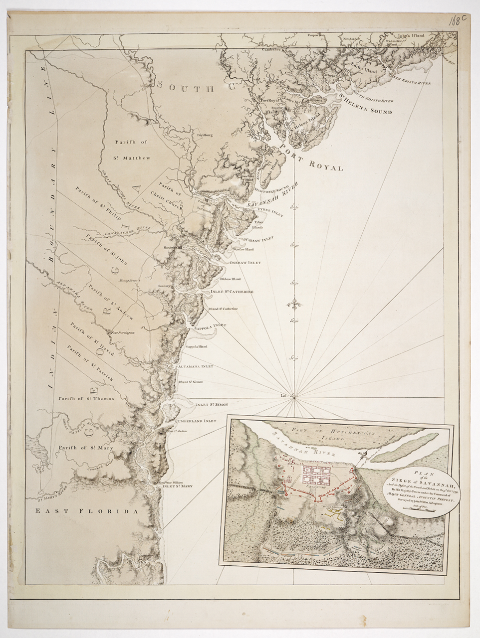
English: [Chart of the coast of Georgia]Single sheet. Engraved. Scale: ca. 1:400 000 (lat). Cartographic Note: Graduated for latitude only. Contents Note: Shows the Indian boundary line. Plate changes: The chart now contains an inset - Plan of the siege of Savannah, and the defeat of the French and Rebels on the 9th Oct 1779, by His Majesty's forces under the command of Major General Augustine Prevost. Surveyed by John Wilson A. Engineer. [ca. 1:17 000 (bar)]. Other features: Printed on Bates paper. Border yellow, land brown. Inset coloured. HNS 168C [Chart of the coast of Georgia] |
| Date | 1780 |
| Dimensions | Plate impression 168A >82.5 x 60.5cm, 168B and 168C 76 x 60.5cm. |
| Source/Photographer | http://collections.rmg.co.uk/collections/objects/560777 |
| Permission (Reusing this file) |
The original artefact or artwork has been assessed as public domain by age, and faithful reproductions of the two dimensional work are also public domain. No permission is required for reuse for any purpose. The text of this image record has been derived from the Royal Museums Greenwich catalogue and image metadata. Individual data and facts such as date, author and title are not copyrightable, but reuse of longer descriptive text from the catalogue may not be considered fair use. Reuse of the text must be attributed to the "National Maritime Museum, Greenwich, London" and a Creative Commons CC-BY-NC-SA-3.0 license may apply if not rewritten. Refer to Royal Museums Greenwich copyright. |
| Identifier | id number: HNS168C previous number: HNS 168 |
| Collection | Charts and maps |
Licensing
edit
|
This is a faithful photographic reproduction of a two-dimensional, public domain work of art. The work of art itself is in the public domain for the following reason:
The official position taken by the Wikimedia Foundation is that "faithful reproductions of two-dimensional public domain works of art are public domain".
This photographic reproduction is therefore also considered to be in the public domain in the United States. In other jurisdictions, re-use of this content may be restricted; see Reuse of PD-Art photographs for details. | ||||
File history
Click on a date/time to view the file as it appeared at that time.
| Date/Time | Thumbnail | Dimensions | User | Comment | |
|---|---|---|---|---|---|
| current | 15:40, 29 August 2017 | | 962 × 1,280 (995 KB) | Fæ (talk | contribs) | Royal Museums Greenwich Charts and maps, http://collections.rmg.co.uk/collections/objects/560777 |
You cannot overwrite this file.
File usage on Commons
The following 2 pages use this file:
_RMG_K0407.jpg&redirect=no)