File:Chesapeake Bay program, monitoring vital signs of the bay. LOC 88690563.jpg

Size of this preview: 389 × 599 pixels. Other resolutions: 156 × 240 pixels | 311 × 480 pixels | 498 × 768 pixels | 665 × 1,024 pixels | 1,329 × 2,048 pixels | 3,376 × 5,200 pixels.
Original file (3,376 × 5,200 pixels, file size: 4.63 MB, MIME type: image/jpeg)
Captions
Captions
Add a one-line explanation of what this file represents
Summary
edit| Description |
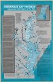
English: Shows water quality monitoring stations, major spawning areas, and degrees of salinity. Includes text, notes, and inset of "The Chesapeake Bay watershed." Available also through the Library of Congress Web site as a raster image. |
||
| Title | Chesapeake Bay program, monitoring vital signs of the bay. | ||
| Shelf ID | G3842.C5C35 1987 .U5 | ||
| Date | |||
| Source | https://www.loc.gov/item/88690563/ | ||
| Author | United States. Environmental Protection Agency | ||
| Permission (Reusing this file) |
|
||
| Other versions |
|
||
| Location | United States · Chesapeake Bay · Maryland · Chesapeake Bay. · Virginia | ||
| Part of | American Memory · Catalog · Geography And Map Division · Additional Conservation And Environment Cartographic Items | ||
| Subject | Chesapeake Bay · Virginia · Salinity · United States · Maps · Water Quality Monitoring Stations · Spawning · Chesapeake Bay (Md. And Va.) · Maryland |

Licensing
edit
| This work is from the Library of Congress. According to the library, there are no known copyright restrictions on the use of this work. |  |
File history
Click on a date/time to view the file as it appeared at that time.
| Date/Time | Thumbnail | Dimensions | User | Comment | |
|---|---|---|---|---|---|
| current | 04:44, 2 June 2018 | | 3,376 × 5,200 (4.63 MB) | Fæ (talk | contribs) | LOC Maps https://www.loc.gov/item/88690563/ #17684 |
You cannot overwrite this file.
File usage on Commons
The following page uses this file: