File:Chesapeake and Ohio Canal National Historical Park, Maryland, Washington D.C., West Virginia LOC 2014585548.tif

Size of this JPG preview of this TIF file: 440 × 600 pixels. Other resolutions: 176 × 240 pixels | 352 × 480 pixels | 563 × 768 pixels | 751 × 1,024 pixels | 1,502 × 2,048 pixels | 5,172 × 7,050 pixels.
Original file (5,172 × 7,050 pixels, file size: 104.32 MB, MIME type: image/tiff)
Captions
Captions
Add a one-line explanation of what this file represents
Summary
edit| Description |
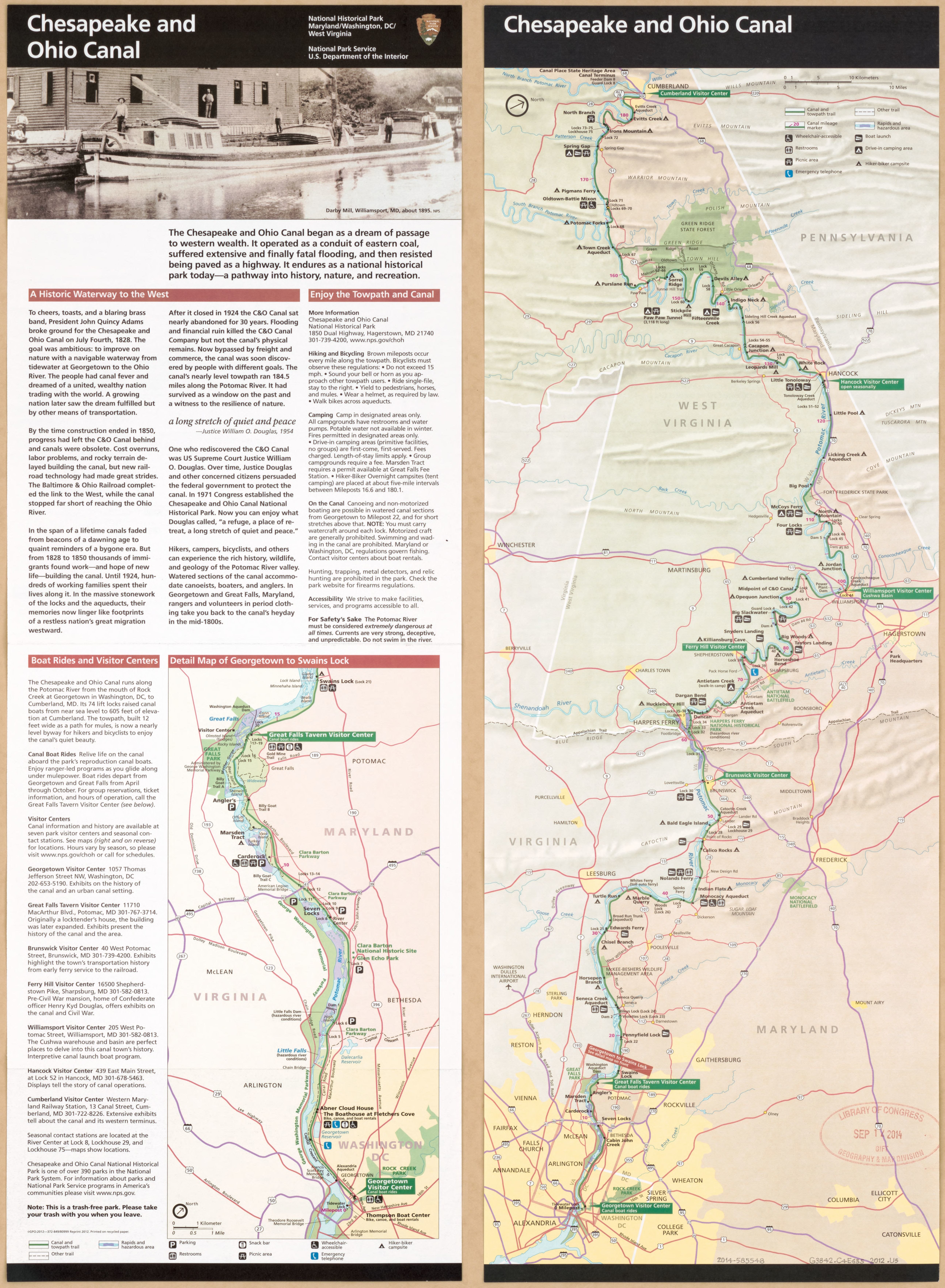
English: Shows canal towpath route and adjacent facilities. Does not show National Park Service property. Title from panel. Relief shown by shading. "*GPO:2012--372-849/80999 Reprint 2012." Oriented with north toward the upper right. Text, "Detail map of Georgetown to Swains Lock", and illustration on verso. Available also through the Library of Congress Web site as a raster image. |
||
| Title | Chesapeake and Ohio Canal National Historical Park, Maryland, Washington D.C., West Virginia | ||
| Shelf ID | G3842.C4E635 2012 .U7 | ||
| Date | |||
| Source | https://www.loc.gov/item/2014585548/ | ||
| Author | United States. National Park Service | ||
| Permission (Reusing this file) |
|
||
| Other versions |
|
||
| Location | Washington D.C. · Chesapeake And Ohio Canal Region. · Chesapeake And Ohio Canal. · Chesapeake And Ohio Canal · Ohio Canal Region · United States · Chesapeake · Chesapeake And Ohio Canal Region · Maryland · Ohio Canal | ||
| Part of | American Memory · General Maps · Catalog · Geography And Map Division | ||
| Subject | Chesapeake And Ohio Canal · United States · Maps · Recreation Areas · Tourist Maps · Chesapeake And Ohio Canal Region · Roads · Chesapeake And Ohio Canal Region (Md. And Washington, D.C.) · Chesapeake And Ohio Canal (Md. And Washington, D.C.) · Maryland · Road Maps |


Licensing
edit| This image or media file contains material based on a work of a National Park Service employee, created as part of that person's official duties. As a work of the U.S. federal government, such work is in the public domain in the United States. See the NPS website and NPS copyright policy for more information. |
File history
Click on a date/time to view the file as it appeared at that time.
| Date/Time | Thumbnail | Dimensions | User | Comment | |
|---|---|---|---|---|---|
| current | 03:03, 9 June 2018 |  | 5,172 × 7,050 (104.32 MB) | Fæ (talk | contribs) | LOC Maps https://www.loc.gov/item/2014585548/ #9204 |
You cannot overwrite this file.
File usage on Commons
The following page uses this file: