File:Coast watch (1979) (20472625608).jpg

Original file(1,302 × 2,614 pixels, file size: 1,022 KB, MIME type: image/jpeg)

Captions

Captions

Add a one-line explanation of what this file represents

Summary

edit
Description
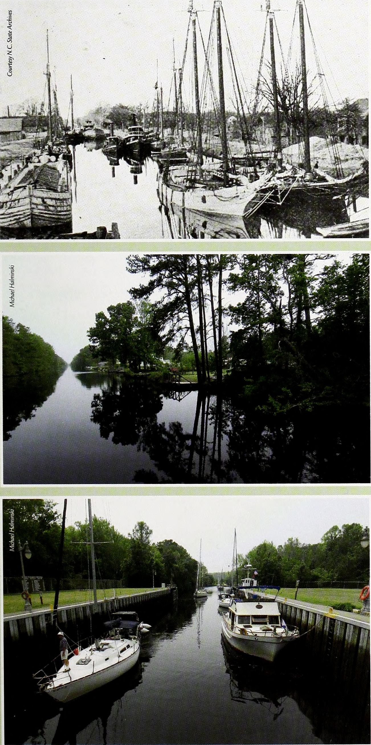
English:
Upper: During the 1800s and early 1900s, many boats and barges went through the Dismal Swamp Canal at South Mills Middle: The canal, which is picturesque and serene, is lined with a variety of trees Lower: Several sailboats and a small yacht go through the locks at South Mills.

Title: Coast watch
Identifier: coastwatch00uncs_19 (find matches)
Year: 1979 (1970s)
Authors: UNC Sea Grant College Program
Subjects: Marine resources; Oceanography; Coastal zone management; Coastal ecology
Publisher: (Raleigh, N. C. : UNC Sea Grant College Program)
Contributing Library: State Library of North Carolina
Digitizing Sponsor: North Carolina Digital Heritage Center

View Book Page: Book Viewer
About This Book: Catalog Entry
View All Images: All Images From Book
Click here to view book online to see this illustration in context in a browseable online version of this book.

Text Appearing Before Image:
TOP TO BOTTOM: During the 1800s and early 1900s, many boats and barges went through the Dismal Swamp Canal at South Mills. • The canal, which is picturesque and serene, is lined with a variety of trees. • Several sailboats and a small yacht go through the locks at South Mills.
Text Appearing After Image:
Over the years, flaws in the canal's original concept and design have caused maintenance problems, according to the Army Corps. Water levels between Deep Creek and the canal's original end in Joyce's Creek were not correctly measured. Even with the Feeder Ditch that supplies water from Lake Drummond, the canal periodically has low water levels. If there is a drought, the canal can be shut down. "However, the Corps has not shut down the locks since 1999," says Peek. For 17 years before that, the canal shut down every fall for droughts, he adds. The locks at Deep Creek and at South Mills hold water between the two points, says Peek, the lockmaster who often entertains boaters by playing tunes on conch shells. "At Deep Creek, it is eight to 12 feet during high tide. At the point where South Mills comes through the Elizabeth River, it is eight feet — give or take." During hurricanes Floyd and Irene, the locks were used as dams, adds Peek. Despite rumors of ceasing the operation of the canal, the Corps has periodically dredged and cleared the canal to keep it open. In 2003, after Hurricane Isabel, the Corps' Norfolk district engineers cleared almost 700 downed trees and other debris. For the fiscal year 2006 that ends Sept. 30, federal funding will be used to operate and maintain the two locks, two bridges and three water-control structures, according to Joel Scussel, Army Corps civil engineer in Norfolk. "In addition, this funding will be used to maintain the 22-mile long canal, including snagging trees and dragging for underwater navigation obstructions," he adds. bnny Blue Inception As an avid sailor and yacht designer, Walter has taken a number of trips on the Dismal Swamp Canal. "I had been going on this route since the 1970s and wanted to design a boat that would cruise on this scenic waterway," explains Walter. "When you go north on the canal, the reflection on the Pasquotank River is gorgeous. So I designed a luxurious passenger boat that would accommodate up to 16 people for overnight voyages." In 2003, Walter and his wife, Bonnie, took the first group down the canal. "The boat was designed after the 1920 steamboat Emnia K that carried freight, mail and passengers on the same route," he says. "It was the last steamboat on the canal. It stopped running in 1921." The double-decker passenger yacht is decorated in a rich decor of polished walnut, tapestry and brass fittings. Passengers can sleep in double cabins with large windows, eat in a dining area, or lounge on two decks to take in the scenic environment. On the second day of a trip, the 72-foot Bonny Blue leaves the docks at Elizabeth City in the morning with its boatload of passengers. The day before, they had traveled along the canal from Deep Creek to Elizabeth City. "I had read about the canal and boat — and seen boats going up and down the canal while driving on Hwy. 17," Patty Koehl of Hertford explains why she's aboard. Before the blue-and-white boat nears the Elizabeth City drawbridge, the blast of its siren pierces the air. Not far from there, Walter points out the spot where he earlier saw five snakes. Further along, the boat passes a bank covered with tall cedar trees that resemble soldiers standing on alert. As the yacht nears Continued Coastwatch I Spring 2006 I www.ncseagrant.org 15

Note About Images

Please note that these images are extracted from scanned page images that may have been digitally enhanced for readability - coloration and appearance of these illustrations may not perfectly resemble the original work.
Date
Source

https://www.flickr.com/photos/internetarchivebookimages/20472625608/

Author Internet Archive Book Images
Permission
(Reusing this file)
At the time of upload, the image license was automatically confirmed using the Flickr API. For more information see Flickr API detail.
Flickr tags
InfoField
  • bookid:coastwatch00uncs_19
  • bookyear:1979
  • bookdecade:1970
  • bookcentury:1900
  • bookauthor:UNC_Sea_Grant_College_Program
  • booksubject:Marine_resources
  • booksubject:Oceanography
  • booksubject:Coastal_zone_management
  • booksubject:Coastal_ecology
  • bookpublisher:_Raleigh_N_C_UNC_Sea_Grant_College_Program_
  • bookcontributor:State_Library_of_North_Carolina
  • booksponsor:North_Carolina_Digital_Heritage_Center
  • bookleafnumber:55
  • bookcollection:statelibrarynorthcarolina
  • bookcollection:ncdhc
  • bookcollection:unclibraries
  • bookcollection:americana
  • BHL Collection
Flickr posted date
InfoField
17 August 2015

Licensing

edit
This image was taken from Flickr's The Commons. The uploading organization may have various reasons for determining that no known copyright restrictions exist, such as:
  1. The copyright is in the public domain because it has expired;
  2. The copyright was injected into the public domain for other reasons, such as failure to adhere to required formalities or conditions;
  3. The institution owns the copyright but is not interested in exercising control; or
  4. The institution has legal rights sufficient to authorize others to use the work without restrictions.

More information can be found at https://flickr.com/commons/usage/.


Please add additional copyright tags to this image if more specific information about copyright status can be determined. See Commons:Licensing for more information.
This image was originally posted to Flickr by Internet Archive Book Images at https://flickr.com/photos/126377022@N07/20472625608. It was reviewed on 8 October 2015 by FlickreviewR and was confirmed to be licensed under the terms of the No known copyright restrictions.

8 October 2015

File history

Click on a date/time to view the file as it appeared at that time.

Date/TimeThumbnailDimensionsUserComment
current17:17, 8 October 2015Thumbnail for version as of 17:17, 8 October 20151,302 × 2,614 (1,022 KB) (talk | contribs)== {{int:filedesc}} == {{information |description={{en|1=<br> '''Title''': Coast watch<br> '''Identifier''': coastwatch00uncs_19 ([https://commons.wikimedia.org/w/index.php?title=Special%3ASearch&profile=default&fulltext=Search&search=insource%3A%2Fcoa...

There are no pages that use this file.