File:Colton's Kansas and Nebraska. LOC 2003627015.jpg

Size of this preview: 385 × 599 pixels. Other resolutions: 154 × 240 pixels | 308 × 480 pixels | 493 × 768 pixels | 658 × 1,024 pixels | 1,316 × 2,048 pixels | 5,194 × 8,081 pixels.
Original file (5,194 × 8,081 pixels, file size: 6.62 MB, MIME type: image/jpeg)
Captions
Captions
Add a one-line explanation of what this file represents
Summary
edit| Description |
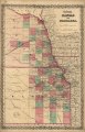
English: Detailed map showing cities and towns, county boundaries, roads, and the railroad network. |
||
| Title | Colton's Kansas and Nebraska. | ||
| Shelf ID | G4200 1855 .C6 TIL | ||
| Date | |||
| Source | https://www.loc.gov/item/2003627015/ | ||
| Author | J.H. Colton & Co. | ||
| Permission (Reusing this file) |
|
||
| Other versions |
|
||
| Location | United States · Kansas · Nebraska | ||
| Part of | American Memory · General Maps · Catalog · Geography And Map Division | ||
| Subject | United States · Maps · Kansas · Nebraska |

Licensing
edit
|
This is a faithful photographic reproduction of a two-dimensional, public domain work of art. The work of art itself is in the public domain for the following reason:
The official position taken by the Wikimedia Foundation is that "faithful reproductions of two-dimensional public domain works of art are public domain".
This photographic reproduction is therefore also considered to be in the public domain in the United States. In other jurisdictions, re-use of this content may be restricted; see Reuse of PD-Art photographs for details. | ||||
File history
Click on a date/time to view the file as it appeared at that time.
| Date/Time | Thumbnail | Dimensions | User | Comment | |
|---|---|---|---|---|---|
| current | 05:29, 26 May 2018 | | 5,194 × 8,081 (6.62 MB) | Fæ (talk | contribs) | LOC Maps https://www.loc.gov/item/2003627015/ #1588 |
You cannot overwrite this file.
File usage on Commons
The following page uses this file: