File:Controllers use radar to direct air traffic 130514-A-RI441-732.jpg
Original file (4,288 × 2,848 pixels, file size: 10.33 MB, MIME type: image/jpeg)
Captions
Summary edit
DescriptionControllers use radar to direct air traffic 130514-A-RI441-732.jpg |
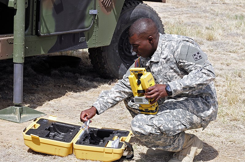
English: U.S. Army Spc. Nathaniel Harden assembles a Theodolite to survey the line of sight of the Air Traffic Navigation, Integration, and Coordination System (ATNAVICS) radar system’s antenna at Butts Army Airfield in Fort Carson, Colo., May 14, 2013. A Theodolite is a precision instrument for measuring angles in the horizontal and vertical planes, and mainly used for surveying applications. Harden is an air traffic controller specialist, with Foxtrot Company, 2nd General Support Aviation Battalion, 4th Aviation Regiment, 4th Combat Aviation Brigade, 4th Infantry Division. (U.S. Army photo by Sgt. Jonathan C. Thibault/Released) |
|||
Date | Taken on 14 May 2013 | |||
Source | https://www.dvidshub.net/image/939763 | |||
Author | Sgt. Jonathan Thibault | |||
Location InfoField | FORT CARSON, CO, US | |||
VIRIN InfoField |
|
|||
Posted InfoField | 23 May 2013, 18:21 | |||
Archive link InfoField | archive copy at the Wayback Machine |
Licensing edit
Public domainPublic domainfalsefalse |
This file is a work of a U.S. Army soldier or employee, taken or made as part of that person's official duties. As a work of the U.S. federal government, it is in the public domain in the United States.
العربية ∙ বাংলা ∙ català ∙ čeština ∙ Deutsch ∙ English ∙ español ∙ eesti ∙ فارسی ∙ suomi ∙ français ∙ hrvatski ∙ magyar ∙ Bahasa Indonesia ∙ italiano ∙ 日本語 ∙ 한국어 ∙ lietuvių ∙ македонски ∙ മലയാളം ∙ မြန်မာဘာသာ ∙ Nederlands ∙ polski ∙ português ∙ русский ∙ sicilianu ∙ српски / srpski ∙ Türkçe ∙ українська ∙ Tiếng Việt ∙ 中文(简体) ∙ 中文(繁體) ∙ +/− |
File history
Click on a date/time to view the file as it appeared at that time.
Date/Time | Thumbnail | Dimensions | User | Comment | |
---|---|---|---|---|---|
current | 15:52, 13 April 2015 | 4,288 × 2,848 (10.33 MB) | Fæ (talk | contribs) | == {{int:filedesc}} == {{milim | description = {{en|1=U.S. Army Spc. Nathaniel Harden assembles a Theodolite to survey the line of sight of the Air Traffic Navigation, Integration, and Coordination System (ATNAVICS) radar system’s antenna at Butts Ar... |
You cannot overwrite this file.
File usage on Commons
There are no pages that use this file.
Metadata
This file contains additional information such as Exif metadata which may have been added by the digital camera, scanner, or software program used to create or digitize it. If the file has been modified from its original state, some details such as the timestamp may not fully reflect those of the original file. The timestamp is only as accurate as the clock in the camera, and it may be completely wrong.
Camera manufacturer | NIKON CORPORATION |
---|---|
Camera model | NIKON D300S |
Exposure time | 1/500 sec (0.002) |
F-number | f/11 |
ISO speed rating | 500 |
Date and time of data generation | 10:55, 14 May 2013 |
Lens focal length | 70 mm |
Short title | 130514-A-RI441-732 |
Author | Fort Carson Public Affairs Office, Sgt. Jonathan Thibault |
Headline | Controllers use radar to direct air traffic |
Image title | U.S. Army Spc. Nathaniel Harden assembles a Theodolite to survey the line of sight of the Air Traffic Navigation, Integration, and Coordination System (ATNAVICS) radar system's antenna at Butts Army Airfield in Fort Carson, Colo., May 14, 2013. A Theodolite is a precision instrument for measuring angles in the horizontal and vertical planes, and mainly used for surveying applications. Harden is an air traffic controller specialist, with Foxtrot Company, 2nd General Support Aviation Battalion, 4th Aviation Regiment, 4th Combat Aviation Brigade, 4th Infantry Division. (U.S. Army photo by Sgt. Jonathan C. Thibault/Released) |
City shown | Fort Carson |
Credit/Provider | U.S. Army |
Source | Digital |
Copyright holder | Public Domain |
Orientation | Normal |
Horizontal resolution | 300 dpi |
Vertical resolution | 300 dpi |
Software used | Adobe Photoshop Elements 10.0 Windows |
File change date and time | 15:29, 14 May 2013 |
White point chromaticity |
|
Chromaticities of primarities |
|
Color space transformation matrix coefficients |
|
Y and C positioning | Co-sited |
Exposure Program | Normal program |
Exif version | 2.21 |
Date and time of digitizing | 10:55, 14 May 2013 |
Meaning of each component |
|
Image compression mode | 4 |
APEX exposure bias | 0 |
Maximum land aperture | 3 APEX (f/2.83) |
Metering mode | Pattern |
Light source | Unknown |
Flash | Flash did not fire |
DateTime subseconds | 48 |
DateTimeOriginal subseconds | 48 |
DateTimeDigitized subseconds | 48 |
Supported Flashpix version | 1 |
Color space | Uncalibrated |
Sensing method | One-chip color area sensor |
File source | Digital still camera |
Scene type | A directly photographed image |
Custom image processing | Normal process |
Exposure mode | Auto exposure |
White balance | Auto white balance |
Digital zoom ratio | 1 |
Focal length in 35 mm film | 105 mm |
Scene capture type | Standard |
Scene control | Low gain up |
Contrast | Normal |
Saturation | Normal |
Sharpness | Normal |
Subject distance range | Unknown |
GPS tag version | 2.2.0.0 |
Supported Flashpix version | 1 |
Image width | 4,288 px |
Image height | 2,848 px |
Date metadata was last modified | 09:29, 14 May 2013 |
Unique ID of original document | xmp.did:94068BE0DCBCE211B28689E251E027A8 |
Keywords |
|
Province or state shown | CO |
Code for country shown | US |
Special instructions | Released
Sgt. Jonathan Thibault Fort Carson Public Affairs Office thaithibault@yahoo.com via DVIDS |
Original transmission location code | U.S. Army |
Country shown | United States |