File:Delaware and Maryland. LOC 2017593569.jpg

Size of this preview: 721 × 600 pixels. Other resolutions: 289 × 240 pixels | 577 × 480 pixels | 923 × 768 pixels | 1,231 × 1,024 pixels | 2,128 × 1,770 pixels.
Original file (2,128 × 1,770 pixels, file size: 690 KB, MIME type: image/jpeg)
Captions
Captions
Add a one-line explanation of what this file represents
Summary
edit| Description |
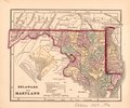
English: General-content state map hand colored to distinguish counties. Relief shown by hachures. Prime meridians: Greenwich and Washington D.C. This map is a page removed from Morse & Gaston's atlas: The diamond atlas with descriptions of all countries. Volume 1, the Western Hemisphere. New York : 1857 (LC classification G1019 .C4515 1857). LC copy imperfect: Torn along lower sheet edge, typewritten source note attached to verso at right-hand sheet edge, adhesive label with inked number affixed to verso. Includes note and inset of Washington D.C. (scale approximately 1:370,000). Available also through the Library of Congress Web site as a raster image. |
||
| Title | Delaware and Maryland. | ||
| Shelf ID | G3830 1857 .M6 | ||
| Date | |||
| Source | https://www.loc.gov/item/2017593569/ | ||
| Author | Morse & Gaston | ||
| Permission (Reusing this file) |
|
||
| Other versions |
|
||
| Location | Washington D.C. · Delaware · Washington · Delaware. · United States · Maryland. · District Of Columbia · Washington. · Maryland | ||
| Part of | American Memory · General Maps · Catalog · Geography And Map Division | ||
| Subject | Washington (D.C.) · Delaware · Washington · United States · Maps · District Of Columbia · Maryland |

Licensing
edit
|
This is a faithful photographic reproduction of a two-dimensional, public domain work of art. The work of art itself is in the public domain for the following reason:
The official position taken by the Wikimedia Foundation is that "faithful reproductions of two-dimensional public domain works of art are public domain".
This photographic reproduction is therefore also considered to be in the public domain in the United States. In other jurisdictions, re-use of this content may be restricted; see Reuse of PD-Art photographs for details. | ||||
File history
Click on a date/time to view the file as it appeared at that time.
| Date/Time | Thumbnail | Dimensions | User | Comment | |
|---|---|---|---|---|---|
| current | 06:42, 23 September 2018 | | 2,128 × 1,770 (690 KB) | Fæ (talk | contribs) | LOC Maps https://www.loc.gov/item/2017593569/ #3899 |
You cannot overwrite this file.
File usage on Commons
The following page uses this file: