File:Die vereinigten Staaten von Nord-America - nach der von Wm. Faden 1783 herausgegebenen Charte, auf welcher alle im englisch americanischen Kriege vorzüglich merkwurdig gewordenen Orter NYPL433752.tiff

Size of this JPG preview of this TIF file: 753 × 600 pixels. Other resolutions: 302 × 240 pixels | 603 × 480 pixels | 965 × 768 pixels | 1,280 × 1,019 pixels | 2,296 × 1,828 pixels.

Original file (2,296 × 1,828 pixels, file size: 12.03 MB, MIME type: image/tiff, 2 pages)
Captions
Captions
Add a one-line explanation of what this file represents
Summary
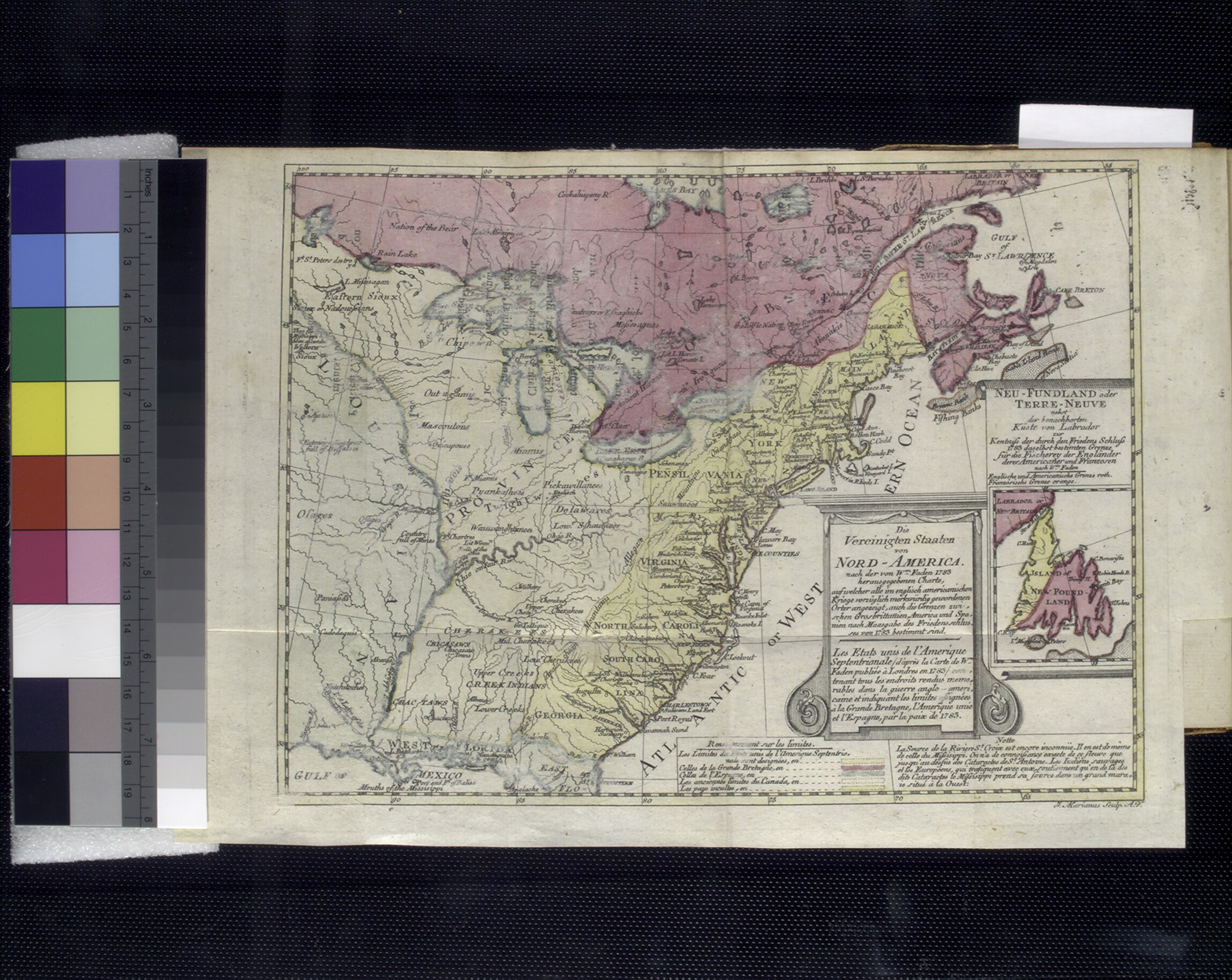
edit| Description | Die vereinigten Staaten von Nord-America : nach der von Wm. Faden 1783 herausgegebenen Charte, auf welcher alle im englisch americanischen Kriege vorzüglich merkwürdig gewordenen Orter angezeigt, auch die Grenzen zwischen Grosbrittanien, America und Spanien nach Maasgabe des Friedensschulusses von 1783 bestimmt sind / T. Marianus, Sculp., A.V.; Lawrence H. Slaughter Collection of English maps, charts, globes, books and atlases / Atlases / Geschichte der Revolution von Nord-America. | |||||||||||||||||||||||
| Notes | Inset: Neu-Fundland oder Terre-Neuve nebst der benachbarten Kste von Labrador. ''Note 2.'') Lawrence H. Slaughter Collection ; 550 K. ''Note 3.'') Relief shown by hachures. | |||||||||||||||||||||||
| Catalogue call number | Map Div. 97-6452 (Map facing p. [1]) [In LHS 3044] | |||||||||||||||||||||||
| Item physical description | 1 map : hand col. ; 19 x 24 cm. folded to 15 x 9 cm. | |||||||||||||||||||||||
| Date | ||||||||||||||||||||||||
| Source |
http://digitalgallery.nypl.org/nypldigital/dgkeysearchdetail.cfm?imageID=433752
|
|||||||||||||||||||||||
| Author | ||||||||||||||||||||||||
| Permission (Reusing this file) |
From The Lionel Pincus and Princess Firyal Map Division. http://maps.nypl.org
|
|||||||||||||||||||||||
| Source description | [8], 272 p. : folded col. map ; 18 cm. | |||||||||||||||||||||||
| Location | Stephen A. Schwarzman Building / The Lionel Pincus and Princess Firyal Map Division | |||||||||||||||||||||||
| Digital item published | 2-26-2005; updated 1-9-2012 | |||||||||||||||||||||||
| Digital ID | 433752 | |||||||||||||||||||||||

The making of this file was supported by Wikimedia UK.
To see other files made with the support of Wikimedia UK, please see the category Supported by Wikimedia UK.
|
File history
Click on a date/time to view the file as it appeared at that time.
| Date/Time | Thumbnail | Dimensions | User | Comment | |
|---|---|---|---|---|---|
| current | 07:42, 26 December 2022 |  | 2,296 × 1,828, 2 pages (12.03 MB) | SamuelJohnson (talk | contribs) | Rotated. |
| 13:22, 29 April 2014 |  | 1,828 × 2,296 (12.01 MB) | Fæ (talk | contribs) | GWToolset:: Creating mediafile for Fæ. Tranche 3 5495-7474 (repairs) |
You cannot overwrite this file.
File usage on Commons
There are no pages that use this file.