File:Doleshnaia Apsha. Wooden Church WDL10054.png
Original file (1,024 × 1,593 pixels, file size: 2.07 MB, MIME type: image/png)
Captions
Captions
Summary edit
| Title |
Русский: Долешная Апша. Деревянная церковь
Français : Doleshnaia Apsha. Église en bois
English: Doleshnaia Apsha. Wooden Church
中文:多雷斯纳阿普萨。木制教堂
Português: Doleshnaia Apsha. Igreja em madeira
العربية: دوليشنايا أبشا. الكنيسة الخشبية
Español: Doleshnaia Apsha. Iglesia de madera |
| Description |
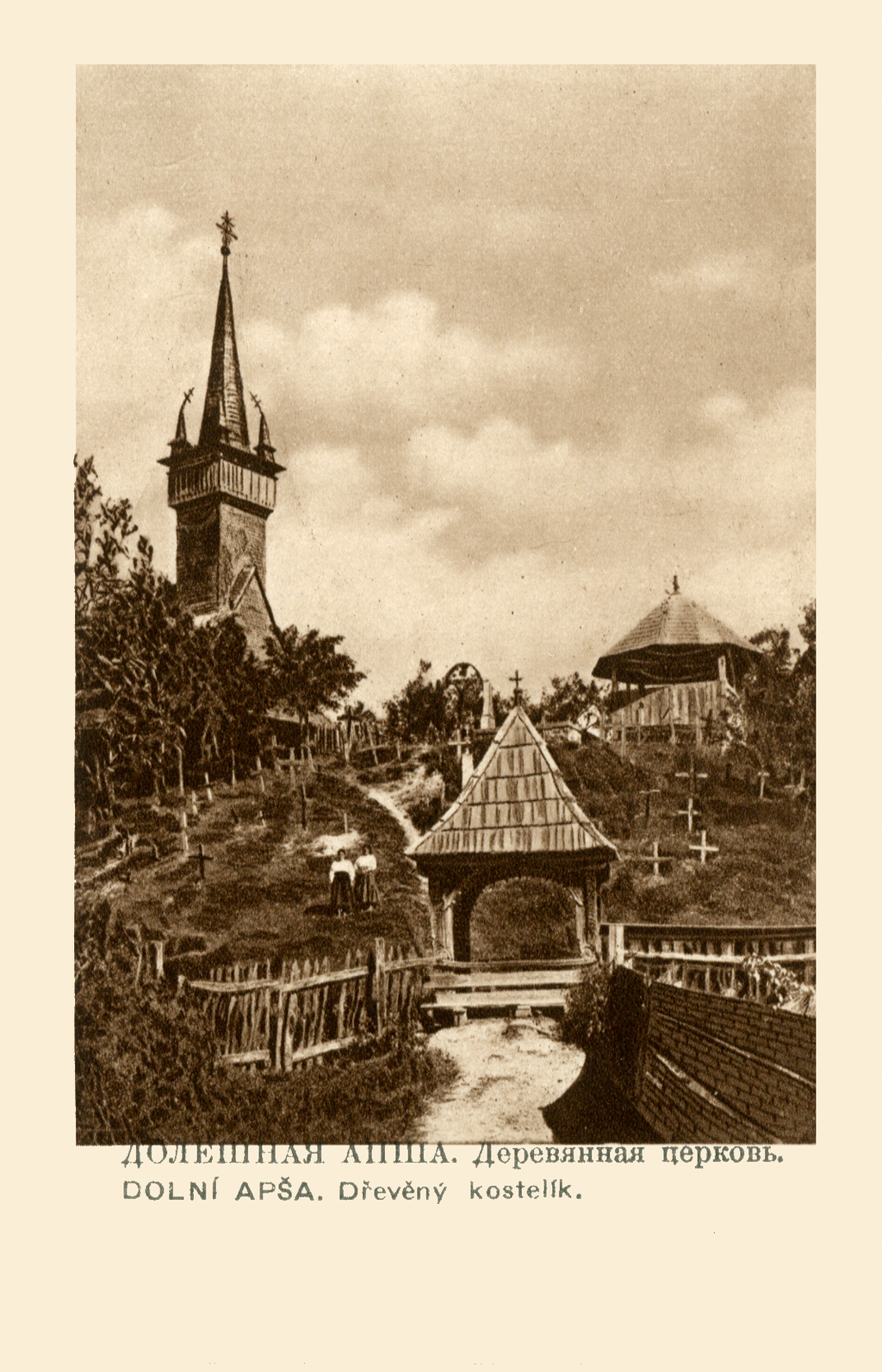
Русский: Снимок входит в альбом, вероятно, опубликованный около 1920 г., который содержит 20 фотографий с видами Подкарпатской Руси. Большая часть этого гористого края до Первой мировой войны принадлежала Австро-Венгрии, а в 1919 г. он вошел в состав нового Чехословацкого государства. Сегодня самая крупная часть Подкарпатской Руси образует Закарпатскую область западной Украины, а меньшие части принадлежат Словакии и Польше. Здесь изображена деревянная церковь в селе Долешная Апша (Нижняя Апша), возведенная на холме над деревней. Элегантный шпиль над квадратной колокольней добавлен позже, во время реставрации церкви в XVIII веке.
Церкви; Шпили; Деревни; Деревянные сооружения Français : Cette image fait partie d'un album probablement publié en 1920 environ et qui contient 20 photographies de scènes de la Ruthénie subcarpatique. Cette région montagneuse, qui faisait essentiellement partie de l'Autriche-Hongrie avant la Première Guerre mondiale, fut intégrée au nouvel État tchécoslovaque en 1919. Aujourd'hui, la majeure partie de la Ruthénie subcarpatique forme l'oblast de Transcarpatie, dans l'ouest de l'Ukraine, avec des terres plus petites en Slovaquie et en Pologne. Cette photographie présente l'église en bois de Dolní Apša (Basse Apsha), qui se dresse sur une colline surplombant le village. L'élégante flèche au-dessus de la tour carrée fut ajoutée ultérieurement, lors de la rénovation de l'église au XVIIIe siècle.
Églises; Flèches; Villages; Bâtiments en bois English: This image is part of an album probably published in about 1920 that contains 20 photographs of scenes in Carpathian Ruthenia, a mountainous region, most of which was part of the Austria-Hungary before World War I, but which became part of the new Czechoslovak state in 1919. Today the largest portion of it forms Zakarpattia Oblast in western Ukraine, with smaller parts in Slovakia and Poland. Shown here is the wooden church in Dolní Apša (Lower Apsha), which rises on a hill above the village. The elegant spire above the square tower was a later addition, made when the church was renovated in the 18th century.
Churches; Spires; Villages; Wooden buildings 中文:这张照片出自《喀尔巴阡-鲁塞尼亚》相册。 该相册可能出版于 1920 年左右, 其中收集了 20 张喀尔巴阡-鲁塞尼亚风景照片。喀尔巴阡-鲁塞尼亚是一个多山的地区,一战之前其大部分属于奥匈帝国,但在 1919 年成为新的国家捷克斯洛伐克的一部分。今天,其最大的部分构成乌克兰西部的外喀尔巴阡州,其余较小部分属于斯洛伐克和波兰。这里显示的是多雷斯纳阿普萨(低地阿普萨)的木制教堂,它位于高出村庄的一座小山上。方形塔上方优雅的尖顶是后来增加的,于 18 世纪教堂翻修时建造。
教堂; 尖顶; 村庄; 木制建筑 Português: Esta imagem faz parte de um álbum, provavelmente publicado por volta de 1920, que contém 20 fotografias de cenas em Rutênia dos Cárpatos, uma região montanhosa, em que grande parte pertencia à Áustria-Hungria antes da Primeira Guerra Mundial, mas que se tornou parte do novo estado da Tchecoslováquia em 1919. Atualmente, a maior parte dela forma o Oblast da Transcarpátia na Ucrânia ocidental, com partes menores na Eslováquia e Polônia. É mostrada aqui a igreja de madeira em Dolní Apša (Parte baixa de Apsha), que surge em uma colina acima do povoado. O elegante pináculo acima da torre quadrada foi incluído posteriormente, feito quando a igreja foi renovada no século XVIII.
Igrejas; Pináculos; Povoados; Construções de madeira العربية: تُعد هذه الصورة جزءًا من ألبوم نُشر على الأرجح حوالي عام 1920، ويحتوي على 20 صورة فوتوغرافية لمناظر في روثينيا الكارباتية، وهي منطقة جبلية كان مُعظمها جزءًا من الإمبراطورية النمساوية المجرية قبل اندلاع الحرب العالمية الأولى، ولكنها أصبحت جزءًا من الدولة التشيكوسلوفاكية الجديدة عام 1919. يقع مُعظم الإقليم حاليًا في مقاطعة زاكارباتيا أوبلاست غرب أوكرانيا، وتوجد أنحاءٌ منه في سلوفاكيا وبولندا. تَظهَر هنا الكنيسة الخشبية في دولني أبشا (أبشا السفلى) التي تستقر فوق أحد التلال أعلى القرية. تمت إضافة القمة المستدقة لاحقًا أعلى البرج المربع عند تجديد الكنيسة إبان القرن الثامن عشر.
الكنائس; القمم المستدقة; القرى; المباني الخشبية Español: Esta imagen pertenece a un álbum, probablemente publicado alrededor de 1920, que contiene 20 fotografías de escenas de la Rutenia carpática, una región montañosa de la que gran parte pertenecía al Imperio austro-húngaro antes de la Primera Guerra Mundial, pero que se convirtió en parte del nuevo Estado checoslovaco en 1919. En la actualidad la mayor parte del territorio forma el óblast de Zakarpatia, en el oeste de Ucrania, mientras que áreas más pequeñas se encuentran en Eslovaquia y Polonia. Aquí se muestra la iglesia de madera de Dolní Apša (baja Apsha), que se eleva en una colina sobre la aldea. La elegante aguja sobre la torre cuadrada fue agregada posteriormente, cuando renovaron la iglesia en el siglo XVIII.
Iglesias; Agujas; Aldeas; Edificios de madera |
| Date | 1920 |
| Collection |
Русский: Национальная парламентская библиотека Украины
Français : Bibliothèque parlementaire nationale d’Ukraine
English: National Parliamentary Library of Ukraine
中文:乌克兰国立国会图书馆
Português: Biblioteca Nacional do Parlamento da Ucrânia
العربية: مكتبة أوكرانيا البرلمانية الوطنية
Español: Biblioteca del Parlamento Nacional de Ucrania |
| Place of creation |
Русский: Европа
Français : Europe
English: Europe
中文:欧洲
Português: Europa
العربية: أوروبا
Español: Europa |
| Notes | Original language title: Долешная Апша. Деревянная церковь |
| Source/Photographer |
|
Licensing edit
|
This is a faithful photographic reproduction of a two-dimensional, public domain work of art. The work of art itself is in the public domain for the following reason:
The official position taken by the Wikimedia Foundation is that "faithful reproductions of two-dimensional public domain works of art are public domain".
This photographic reproduction is therefore also considered to be in the public domain in the United States. In other jurisdictions, re-use of this content may be restricted; see Reuse of PD-Art photographs for details. | ||||
File history
Click on a date/time to view the file as it appeared at that time.
| Date/Time | Thumbnail | Dimensions | User | Comment | |
|---|---|---|---|---|---|
| current | 18:46, 27 February 2014 | | 1,024 × 1,593 (2.07 MB) | Fæ (talk | contribs) | =={{int:filedesc}}== {{Artwork |artist = |author = |title ={{ru|1=Долешная Апша. Деревянная церковь}} {{fr|1=Doleshnaia Apsha. Église en bois}} {{en|1=Doleshnaia Apsha. Wooden Church}} {{zh|1=多雷斯纳阿普萨。木制... |
You cannot overwrite this file.
File usage on Commons
The following page uses this file: