File:Early-medieval Thomas Class B, Type 4 strap end (FindID 776536).jpg

Size of this preview: 564 × 599 pixels. Other resolutions: 226 × 240 pixels | 452 × 480 pixels | 723 × 768 pixels | 964 × 1,024 pixels | 1,928 × 2,048 pixels | 4,479 × 4,757 pixels.
Original file (4,479 × 4,757 pixels, file size: 4.94 MB, MIME type: image/jpeg)
Captions
Captions
Add a one-line explanation of what this file represents
Summary
edit.jpg&action=edit§ion=1)
| Early-medieval Thomas Class B, Type 4 strap end | |||
|---|---|---|---|
| Photographer |
Derby Museums Trust, Alastair Willis, 2016-04-04 11:23:30 |
||
| Title |
Early-medieval Thomas Class B, Type 4 strap end |
||
| Description |
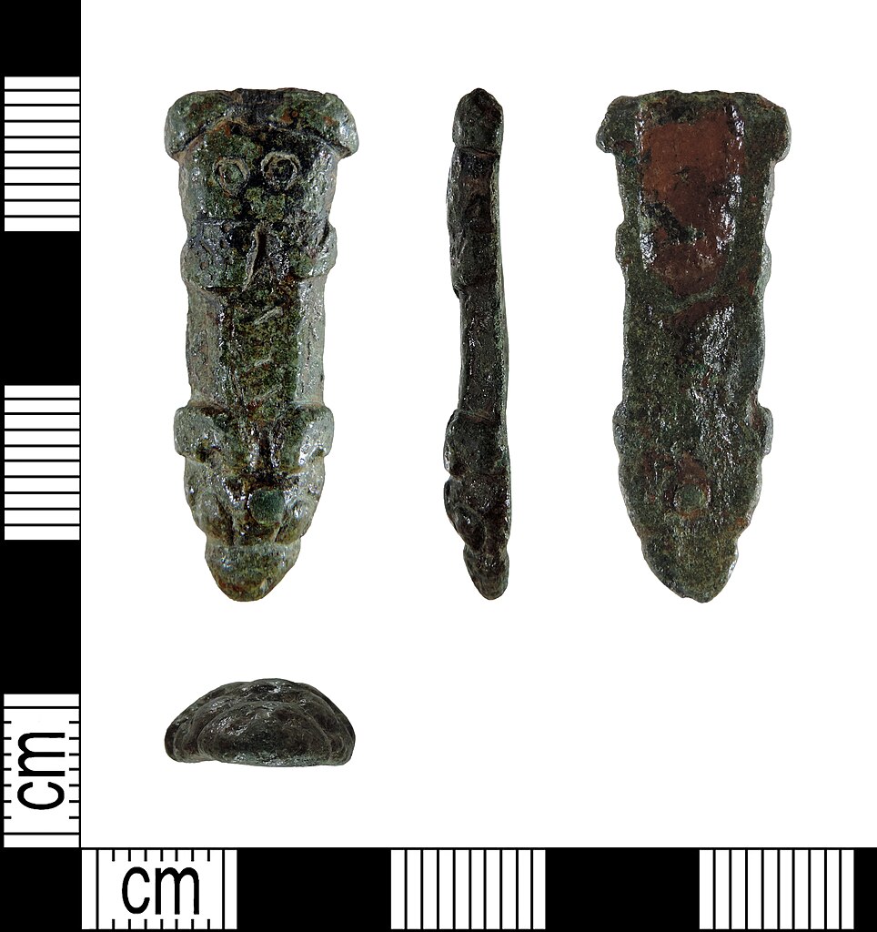
English: An incomplete copper alloy early-medieval/Anglo-Saxon/Viking strap end (AD c.800-c.1100), missing its attachment end. Overall, the object measures 34.8mm long, 13.2mm wide and 4.5mm thick. It weighs 6.4g. The strap end has broadly parallel sides and a trapezoidal cross-section. It has a pointed zoomorphic terminal, which is moulded and represents an animal head with large semi-circular eyes and ears. Above the head is a short rectangular shaft with bevelled side edges. This part is decorated with a zigzagged pattern which may represent a snake. Above the shaft is a moulded stylised human or animal head. The strap end is therefore a Thomas (2004) Class B Type 4 strap end (Multi-headed). There is a copper alloy rivet through the zoomorphic terminal which may have been added later, perhaps as a repair. |
||
| Depicted place | (County of findspot) Nottinghamshire | ||
| Date | between 800 and 1100 | ||
| Accession number |
FindID: 776536 Old ref: DENO-E40172 Filename: DENOE40172.jpg |
||
| Credit line |
|
||
| Source |
https://finds.org.uk/database/ajax/download/id/561501 Catalog: https://finds.org.uk/database/images/image/id/561501/recordtype/artefacts archive copy at the Wayback Machine Artefact: https://finds.org.uk/database/artefacts/record/id/776536 |
||
| Permission (Reusing this file) |
Attribution License | ||
| Object location | | View this and other nearby images on: OpenStreetMap |
|---|
.jpg¶ms=052.878300_N_-001.239500_E_globe:Earth_class:object_type:object__&language=en)
Licensing
edit.jpg&action=edit§ion=2)
This file is licensed under the Creative Commons Attribution 2.0 Generic license.
Attribution: Derby Museums Trust
- You are free:
- to share – to copy, distribute and transmit the work
- to remix – to adapt the work
- Under the following conditions:
- attribution – You must give appropriate credit, provide a link to the license, and indicate if changes were made. You may do so in any reasonable manner, but not in any way that suggests the licensor endorses you or your use.
File history
Click on a date/time to view the file as it appeared at that time.
| Date/Time | Thumbnail | Dimensions | User | Comment | |
|---|---|---|---|---|---|
| current | 14:06, 10 February 2019 | | 4,479 × 4,757 (4.94 MB) | Fæ (talk | contribs) | Portable Antiquities Scheme, DENO, FindID: 776536, early medieval, page 4287, batch count 2304 |
You cannot overwrite this file.
File usage on Commons
The following page uses this file:
.jpg)
.jpg&oldid=546613477)