File:Early Medieval girdle hanger (FindID 801417).jpg

Size of this preview: 600 × 600 pixels. Other resolutions: 240 × 240 pixels | 480 × 480 pixels | 768 × 768 pixels | 1,024 × 1,024 pixels | 2,048 × 2,048 pixels | 3,972 × 3,972 pixels.
Original file (3,972 × 3,972 pixels, file size: 3.65 MB, MIME type: image/jpeg)
Captions
Captions
Add a one-line explanation of what this file represents
Summary
edit.jpg&action=edit§ion=1)
| Early Medieval girdle hanger | |||
|---|---|---|---|
| Photographer |
Derby Museums Trust, Alastair Willis, 2016-12-19 15:29:09 |
||
| Title |
Early Medieval girdle hanger |
||
| Description |
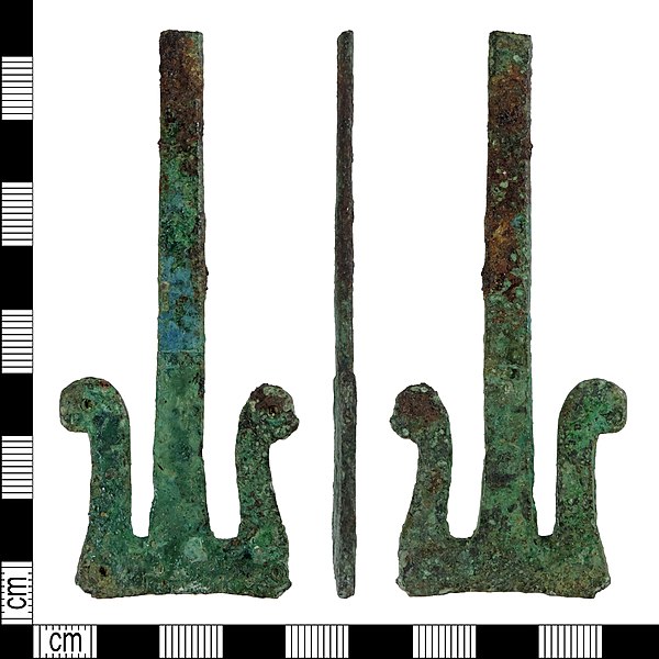
English: An incomplete copper alloy girdle hanger of early medieval date. The suspension loop is missing, the shank neck terminating in a clean break, probably old. Overall, the shape is similar to an inverted T with elaborate arms. The shaft is rectangular, expanding slightly towards the bottom. It has a flat rectangular cross-section. The terminal has concave sides and both arms have outward scrolling ends. The front surface is decorated with a border of small stamped cresents along the edges and a pair of incised lines running horizontally across the shaft 36 mm from the base. Ther are also four deeper circular holes, one at the each of the bottom corners and one at each end of the arms. The reverse surface seems plain. The object is 87 mm long, the terminal is 31 mm wide at the base, and the object weighs 24.85 g. |
||
| Depicted place | (County of findspot) Lincolnshire | ||
| Date | between 480 and 550 | ||
| Accession number |
FindID: 801417 Old ref: DENO-562145 Filename: DENO562145.jpg |
||
| Credit line |
|
||
| Source |
https://finds.org.uk/database/ajax/download/id/595009 Catalog: https://finds.org.uk/database/images/image/id/595009/recordtype/artefacts archive copy at the Wayback Machine Artefact: https://finds.org.uk/database/artefacts/record/id/801417 |
||
| Permission (Reusing this file) |
Attribution License version 2.0 (verified 13 November 2020) | ||
| Object location | | View this and other nearby images on: OpenStreetMap |
|---|
.jpg¶ms=053.007900_N_-000.726460_E_globe:Earth_class:object_type:object__&language=en)
Licensing
edit.jpg&action=edit§ion=2)
This file is licensed under the Creative Commons Attribution 2.0 Generic license.
Attribution: Derby Museums Trust
- You are free:
- to share – to copy, distribute and transmit the work
- to remix – to adapt the work
- Under the following conditions:
- attribution – You must give appropriate credit, provide a link to the license, and indicate if changes were made. You may do so in any reasonable manner, but not in any way that suggests the licensor endorses you or your use.
File history
Click on a date/time to view the file as it appeared at that time.
| Date/Time | Thumbnail | Dimensions | User | Comment | |
|---|---|---|---|---|---|
| current | 14:05, 19 December 2018 | | 3,972 × 3,972 (3.65 MB) | Fæ (talk | contribs) | Portable Antiquities Scheme, DENO, FindID: 801417, early medieval, page 2649, batch count 3488 |
You cannot overwrite this file.
File usage on Commons
The following page uses this file:
.jpg)
.jpg&oldid=642449676)