File:Eritrea 1-100,000 LOC 2009578536-6.jpg

Size of this preview: 471 × 599 pixels. Other resolutions: 189 × 240 pixels | 377 × 480 pixels | 604 × 768 pixels | 805 × 1,024 pixels | 1,610 × 2,048 pixels | 5,123 × 6,517 pixels.
Original file (5,123 × 6,517 pixels, file size: 4.91 MB, MIME type: image/jpeg)
Captions
Captions
Add a one-line explanation of what this file represents
Summary
edit| Description |
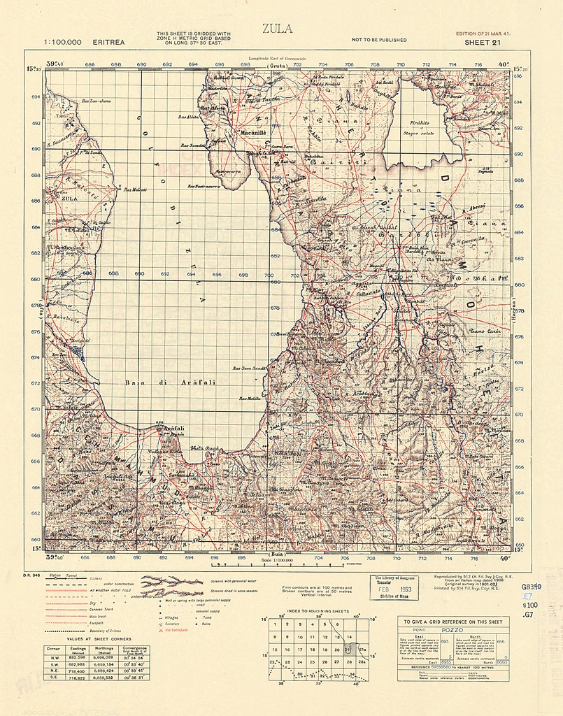
English: Relief shown by hachures, form lines, and spot heights. Geographic features in Italian. Title and legend in English. Some sheets by the 512 Army Field Survey Company, Royal Engineers. Reprinted from various editions originally published by the Istituto geografico militare, Italy. Index to adjoining sheets on verso. Available also through the Library of Congress Web site as a raster image. |
||
| Title | Eritrea 1:100,000 | ||
| Shelf ID | G8340 s100 .G7 | ||
| Parent | https://www.loc.gov/resource/g8340m.g2009578536/ | ||
| Sheet title | Image 6 of Eritrea 1:100,000 | ||
| Date | |||
| Source | https://www.loc.gov/item/2009578536/ | ||
| Author | Great Britain. Army. Royal Engineers. Field Survey Coy., 514Th.; Istituto Geografico Militare (Italy) | ||
| Permission (Reusing this file) |
|
||
| Other versions |
|
||
| Location | Eritrea | ||
| Part of | American Memory · General Maps · Catalog · Geography And Map Division | ||
| Subject | Eritrea · Maps |


Licensing
edit
This work is in the public domain in the United States because it is a work prepared by an officer or employee of the United States Government as part of that person’s official duties under the terms of Title 17, Chapter 1, Section 105 of the US Code.
Note: This only applies to original works of the Federal Government and not to the work of any individual U.S. state, territory, commonwealth, county, municipality, or any other subdivision. This template also does not apply to postage stamp designs published by the United States Postal Service since 1978. (See § 313.6(C)(1) of Compendium of U.S. Copyright Office Practices). It also does not apply to certain US coins; see The US Mint Terms of Use.
|
 | |
| This file has been identified as being free of known restrictions under copyright law, including all related and neighboring rights. | ||
File history
Click on a date/time to view the file as it appeared at that time.
| Date/Time | Thumbnail | Dimensions | User | Comment | |
|---|---|---|---|---|---|
| current | 14:33, 21 May 2018 | | 5,123 × 6,517 (4.91 MB) | Fæ (talk | contribs) | LOC Maps multisheet https://www.loc.gov/item/2009578536/ sheet 6 of 17 #9260 |
You cannot overwrite this file.
File usage on Commons
The following page uses this file: