File:Eye of the storm ESA366582.jpg

Original file (1,228 × 949 pixels, file size: 899 KB, MIME type: image/jpeg)
Captions
Captions
Summary edit
| DescriptionEye of the storm ESA366582.jpg |
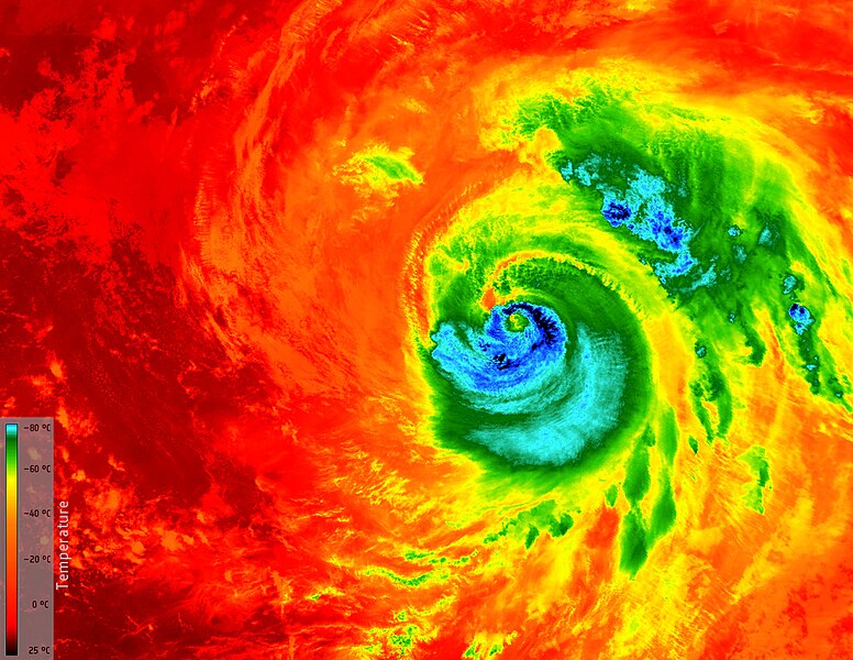
English: This image from Copernicus Sentinel-3A shows the temperature at the top of Hurricane Matthew at 03:13 GMT (05:13 CEST) today, as it approached Florida in the USA.
The temperature of the clouds at the top of the storm, about 12 km from the ocean surface, range from about –80°C just outside the eye of the storm to about 25°C at sea level in the Gulf of Mexico, where it is relatively calm. This monster 400 km-wide hurricane was about 200 km northwest of Miami Beach when the image was taken. Having already caused devastation in the Caribbean, Matthew is the most powerful hurricane to threaten the US Atlantic coast in more than a decade – and it is thought that it could be the most catastrophic to hit Florida in more than a 100 years. Sentinel-3’s sea and land surface temperature radiometer measures energy radiating from Earth’s surface in nine spectral bands. This is a thermal infrared image at a resolution of 1 km. |
| Date | |
| Source | http://www.esa.int/spaceinimages/Images/2016/10/Eye_of_the_storm |
| Author | European Space Agency |
| Permission (Reusing this file) |
contains modified Copernicus Sentinel data (2016), processed by ESA,CC BY-SA 3.0 IGO |
| Title InfoField | Eye of the storm |
| Mission InfoField | Sentinel-3 |
| Activity InfoField | Observing the Earth |
Licensing edit
- You are free:
- to share – to copy, distribute and transmit the work
- to remix – to adapt the work
- Under the following conditions:
- attribution – You must give appropriate credit, provide a link to the license, and indicate if changes were made. You may do so in any reasonable manner, but not in any way that suggests the licensor endorses you or your use.
- share alike – If you remix, transform, or build upon the material, you must distribute your contributions under the same or compatible license as the original.

File history
Click on a date/time to view the file as it appeared at that time.
| Date/Time | Thumbnail | Dimensions | User | Comment | |
|---|---|---|---|---|---|
| current | 15:40, 6 May 2017 |  | 1,228 × 949 (899 KB) | Fæ (talk | contribs) | == {{int:filedesc}} == {{information | description = {{en|1=This image from Copernicus Sentinel-3A shows the temperature at the top of Hurricane Matthew at 03:13 GMT (05:13 CEST) today, as it approached Florida in the USA. The temperature of the clouds... |
You cannot overwrite this file.
File usage on Commons
There are no pages that use this file.
Metadata
This file contains additional information such as Exif metadata which may have been added by the digital camera, scanner, or software program used to create or digitize it. If the file has been modified from its original state, some details such as the timestamp may not fully reflect those of the original file. The timestamp is only as accurate as the clock in the camera, and it may be completely wrong.
| Width | 1,228 px |
|---|---|
| Height | 949 px |
| Bits per component |
|
| Compression scheme | LZW |
| Pixel composition | RGB |
| Orientation | Normal |
| Number of components | 3 |
| Horizontal resolution | 72 dpi |
| Vertical resolution | 72 dpi |
| Data arrangement | chunky format |
| Software used | Adobe Photoshop CS5.1 Windows |
| File change date and time | 15:09, 7 October 2016 |
| Color space | Uncalibrated |
| Date and time of digitizing | 15:46, 7 October 2016 |
| Date metadata was last modified | 17:09, 7 October 2016 |
| Unique ID of original document | xmp.did:FE9B9DCB878CE611A071AE53BB9795B5 |
| IIM version | 1 |