File:Fall Color Around Lake Superior, Image of the Day DVIDS858445.jpg
![File:Fall Color Around Lake Superior, Image of the Day DVIDS858445.jpg](https://upload.wikimedia.org/wikipedia/commons/thumb/a/af/Fall_Color_Around_Lake_Superior%2C_Image_of_the_Day_DVIDS858445.jpg/780px-Fall_Color_Around_Lake_Superior%2C_Image_of_the_Day_DVIDS858445.jpg?20150419135838)
Size of this preview: 780 × 600 pixels. Other resolutions: 312 × 240 pixels | 624 × 480 pixels | 999 × 768 pixels | 1,280 × 985 pixels | 2,560 × 1,969 pixels | 5,200 × 4,000 pixels.
Original file (5,200 × 4,000 pixels, file size: 3.89 MB, MIME type: image/jpeg)
File information
Structured data
Captions
Captions
Add a one-line explanation of what this file represents
Summary
editDescriptionFall Color Around Lake Superior, Image of the Day DVIDS858445.jpg |
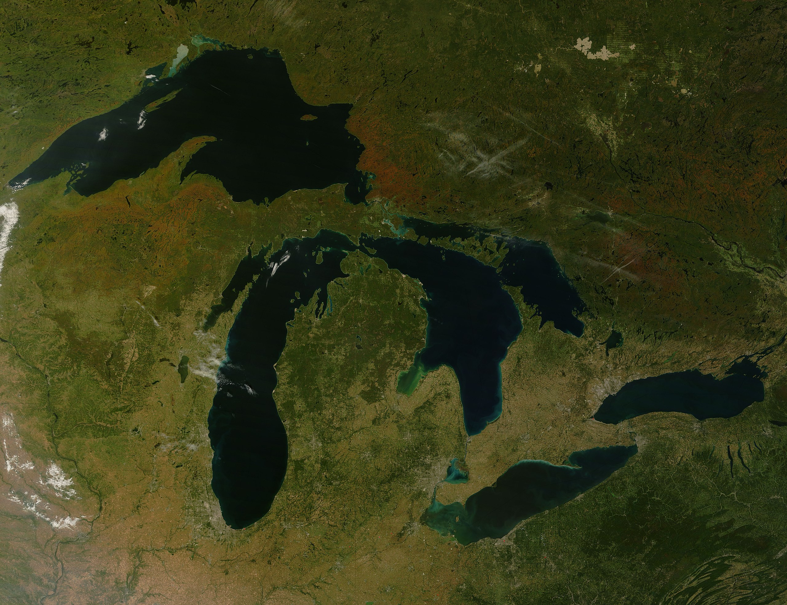
English: The calendar may have set September 23 as the first day of autumn in 2007, but the forests that line the eastern shore of Lake Superior had already started to mark the turning of the season. By September 23, when the Moderate Resolution Imaging Spectroradiometer ( modis.gsfc.nasa.gov MODIS ) on NASA's terra.nasa.gov/ Terra satellite captured this photo-like image, the forests of northern Michigan and southern Ontario flamed orange as the first trees of the season -- maples -- began to display their brilliant red and orange fall colors. Veins of green run through the sea of orange where the deciduous forest gives way to deep green pine trees. |
Date | |
Source | https://www.dvidshub.net/image/858445 |
Author |
This file is lacking author information.
|
Location InfoField | WASHINGTON, D.C., US |
Posted InfoField | 8 February 2013, 20:34 |
DVIDS ID InfoField | 858445 |
Archive link InfoField | archive copy at the Wayback Machine |
Licensing
editPublic domainPublic domainfalsefalse |
![]() |
This file is in the public domain in the United States because it was solely created by NASA. NASA copyright policy states that "NASA material is not protected by copyright unless noted". (See Template:PD-USGov, NASA copyright policy page or JPL Image Use Policy.) | ![]() |
![]() |
Warnings:
|
File history
Click on a date/time to view the file as it appeared at that time.
Date/Time | Thumbnail | Dimensions | User | Comment | |
---|---|---|---|---|---|
current | 13:58, 19 April 2015 | ![]() | 5,200 × 4,000 (3.89 MB) | Fæ (talk | contribs) | == {{int:filedesc}} == {{milim | description = {{en|1=The calendar may have set September 23 as the first day of autumn in 2007, but the forests that line the eastern shore of Lake Superior had already started to mark the turning of the season. By Sept... |
You cannot overwrite this file.
File usage on Commons
There are no pages that use this file.
Metadata
This file contains additional information such as Exif metadata which may have been added by the digital camera, scanner, or software program used to create or digitize it. If the file has been modified from its original state, some details such as the timestamp may not fully reflect those of the original file. The timestamp is only as accurate as the clock in the camera, and it may be completely wrong.
Author | NASA, Courtesy Photo |
---|---|
Headline | Fall Color Around Lake Superior: Image of the Day |
Image title | The calendar may have set September 23 as the first day of autumn in 2007, but the forests that line the eastern shore of Lake Superior had already started to mark the turning of the season. By September 23, when the Moderate Resolution Imaging Spectroradiometer ( modis.gsfc.nasa.gov MODIS ) on NASA's terra.nasa.gov/ Terra satellite captured this photo-like image, the forests of northern Michigan and southern Ontario flamed orange as the first trees of the season -- maples -- began to display their brilliant red and orange fall colors. Veins of green run through the sea of orange where the deciduous forest gives way to deep green pine trees. <p>The most vivid color is concentrated in Canada's province of Ontario. Located farther south, Michigan's trees show only a hint of color. The St. Mary's River seems to be the dividing line between the brightest colors and the as-yet-unchanged forest. The river is also the border between the United States and Canada, as well as the only waterway linking Lake Superior to the rest of the Great Lakes. Orange and green forest gives way to gray along the banks of the river where the cities of Sault St. Marie, Ontario, and Sault St. Marie, Michigan, are located. Separated into two cities by the split between Canada and the United States after the Revolutionary War, the city was the first permanent European settlement in either Ontario or Michigan. A faint tan line spanning the river is the bridge that links the two cities. The pale green grid south of Sault St. Marie, Michigan, reveals patterns of land use, either from agriculture or forestry.</p> <p>The large image provides an unusually cloud-free view of all of the Great Lakes. Similar spots of color stretch across southern Canada and parts of Michigan, Wisconsin, and Minnesota. The northern plains of the United States have started to turn yellow as grasses ripen, but the eastern forests in Pennsylvania and New York remain deep green. Red squares scattered throughout the large image mark the locations of fires. The large image is at MODIS' maximum resolution of 250 meters per pixel. The image is available in rapidfire.sci.gsfc.nasa.gov/gallery/?2007266-0923/GreatLakes.A2007266.1630.1km.jpg additional resolutions from the MODIS Rapid Response System.</p> <ul><li> http://www.northshorevisitor.com/fall-colors/fall-color-report.html#gth Fall Color Report 2007, Accessed September 25, 2007. </li> <li> www.saultstemarie.com/ Sault St. Marie Visitor's Bureau Accessed September 25, 2007.</li> </ul> NASA Identifier: ge_08084 |
City shown | Washington |
Credit/Provider | U.S. Civilian |
Source | Digital |
Copyright holder | Public Domain |
Keywords |
|
Province or state shown | D.C. |
Code for country shown | US |
Country shown | US |
Original transmission location code | ge_08084 |