File:Flooded areas- Cuyahoga River, mile 18.6 to ... 40.25. LOC gm70002190.tif

Size of this JPG preview of this TIF file: 800 × 573 pixels. Other resolutions: 320 × 229 pixels | 640 × 458 pixels | 1,024 × 733 pixels | 1,280 × 916 pixels | 2,560 × 1,833 pixels | 7,972 × 5,708 pixels.
Original file (7,972 × 5,708 pixels, file size: 130.19 MB, MIME type: image/tiff)
Captions
Captions
Add a one-line explanation of what this file represents
Summary edit
| Description |
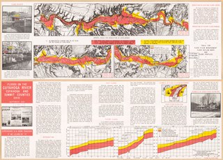
English: Scale ca. 1:32,000. Folded title: Floods on the Cuyahoga River, Cuyahoga and Summit counties, Ohio. Relief shown by contours. Includes text and col. illus. Profiles showing "flood elevations" on verso. Available also through the Library of Congress Web site as a raster image. AACR2 |
||
| Title | Flooded areas: Cuyahoga River, mile 18.6 to ... 40.25. | ||
| Shelf ID | G4082.C8 1969 .U5 | ||
| Date | |||
| Source | https://www.loc.gov/item/gm70002190/ | ||
| Author | United States. Army. Corps Of Engineers | ||
| Permission (Reusing this file) |
|
||
| Other versions |
|
||
| Location | Cuyahoga River. · Cuyahoga County · United States · Cuyahoga River · Cuyahoga County. · Summit County · Ohio · Summit County. | ||
| Part of | American Memory · Catalog · Geography And Map Division · Additional Conservation And Environment Cartographic Items | ||
| Subject | Cuyahoga County · Floods · United States · Maps · Cuyahoga River · Summit County · Ohio |


Licensing edit
| This work is from the Library of Congress. According to the library, there are no known copyright restrictions on the use of this work. |  |
File history
Click on a date/time to view the file as it appeared at that time.
| Date/Time | Thumbnail | Dimensions | User | Comment | |
|---|---|---|---|---|---|
| current | 05:54, 8 March 2020 |  | 7,972 × 5,708 (130.19 MB) | Fæ (talk | contribs) | LOC Maps https://www.loc.gov/item/gm70002190/ #38028 |
You cannot overwrite this file.
File usage on Commons
The following page uses this file: