File:Florette growth center, year 2000, soil suitability for septic tanks, Morgan County, Alabama LOC 82692927.jpg

Size of this preview: 800 × 494 pixels. Other resolutions: 320 × 198 pixels | 640 × 395 pixels | 1,024 × 632 pixels | 1,280 × 790 pixels | 2,560 × 1,580 pixels | 6,617 × 4,084 pixels.
Original file (6,617 × 4,084 pixels, file size: 1.87 MB, MIME type: image/jpeg)
Captions
Captions
Add a one-line explanation of what this file represents
Summary edit
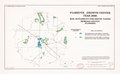
| Description |
English: "February 1980 Base 4-R-37110-17." "Base compiled from latest USGS quad sheets." Includes location maps. Available also through the Library of Congress Web site as a raster image. |
||
| Title | Florette growth center, year 2000, soil suitability for septic tanks, Morgan County, Alabama | ||
| Shelf ID | G3974.F52N46 1980 .U5 | ||
| Date | |||
| Source | https://www.loc.gov/item/82692927/ | ||
| Author | United States. Soil Conservation Service | ||
| Permission (Reusing this file) |
|
||
| Other versions |
|
||
| Location | United States · Alabama · Florette · Florette. | ||
| Part of | American Memory · Cities And Towns · Catalog · Geography And Map Division · Additional Conservation And Environment Cartographic Items | ||
| Subject | Florette · United States · Maps · Soil Absorption And Adsorption · Sewage Disposal In The Ground · Alabama · Septic Tanks |

Licensing edit
| This work is from the Library of Congress. According to the library, there are no known copyright restrictions on the use of this work. |  |
File history
Click on a date/time to view the file as it appeared at that time.
| Date/Time | Thumbnail | Dimensions | User | Comment | |
|---|---|---|---|---|---|
| current | 11:19, 13 March 2019 | | 6,617 × 4,084 (1.87 MB) | Fæ (talk | contribs) | LOC Maps https://www.loc.gov/item/82692927/ #4851 |
You cannot overwrite this file.
File usage on Commons
The following page uses this file: