File:Fogo, Cabo Verde ESA411784.tiff

Original file (3,840 × 2,160 pixels, file size: 47.48 MB, MIME type: image/tiff)
Captions
Captions
Summary
edit| Description |
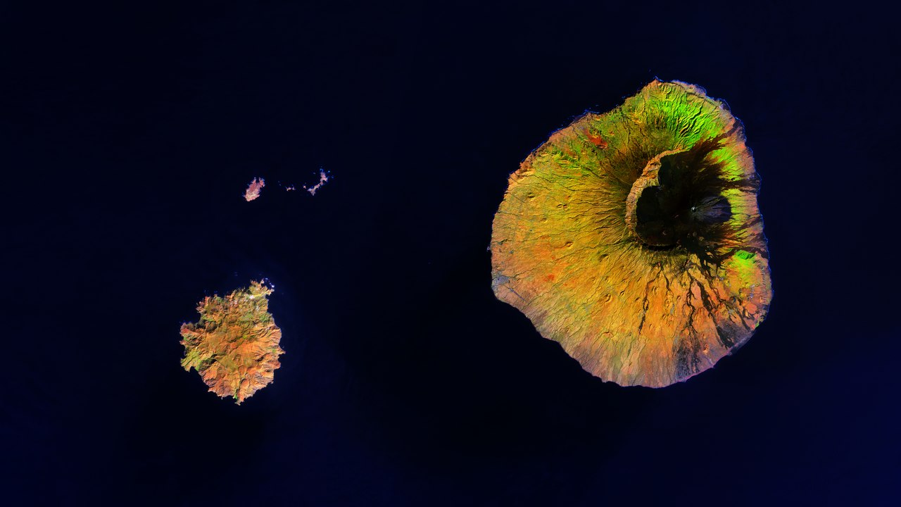
English: The Copernicus Sentinel-2A satellite takes us over Fogo, Cabo Verde. This small volcanic island, which can be seen in the right of the image, is about 25 km in diameter and home to around 35 000 people. The combined population of the nine inhabited islands that make up the Republic of Cabo Verde is estimated to be 550 000. These islands lie in the Atlantic Ocean, around 600 km off the west coast of Africa.
The black area in the island’s centre is the crater of the Pico do Fogo – Fogo’s highest point stands at 2800 m, and is also the highest peak in the entire Republic of Cabo Verde. It last erupted in November 2014 to February 2015, totalling 77 days of activity. In some places to 75% of the buildings were destroyed, mostly by lava. In the northeast of the island, vibrant green highlights a vegetated area, where coffee is grown. There is a long tradition of coffee growing here, although the semi-arid climate and reduced rainfall in recent years make this a challenge. Other crops grown on the island include peanuts, oranges, tobacco, and beans. More arid and rocky areas are shown in a mix of yellow and orange. In the bottom left of the image we can see the island of Brava, with three islets above: Rombos–Grande, Luís Carneiro, and Cima. The Sentinel-2 mission for Europe’s Copernicus programme monitors our changing lands. This image, which was captured on 22 January 2018, is also featured on theEarth from Space video programme. |
| Date | |
| Source | http://www.esa.int/spaceinimages/Images/2018/11/Fogo_Cabo_Verde |
| Author | European Space Agency |
| Permission (Reusing this file) |
contains modified Copernicus Sentinel data (2018), processed by ESA ,CC BY-SA 3.0 IGO |
| Title | Fogo, Cabo Verde |
| System | Copernicus |
| Set | Earth observation image of the week |
| Mission | Sentinel-2 |
| Activity | Observing the Earth |
Licensing
edit- You are free:
- to share – to copy, distribute and transmit the work
- to remix – to adapt the work
- Under the following conditions:
- attribution – You must give appropriate credit, provide a link to the license, and indicate if changes were made. You may do so in any reasonable manner, but not in any way that suggests the licensor endorses you or your use.
- share alike – If you remix, transform, or build upon the material, you must distribute your contributions under the same or compatible license as the original.

|
This image contains data from a satellite in the Copernicus Programme, such as Sentinel-1, Sentinel-2 or Sentinel-3. Attribution is required when using this image.
Attribution: Contains modified Copernicus Sentinel data {{{year}}}
The use of Copernicus Sentinel Data is regulated under EU law (Commission Delegated Regulation (EU) No 1159/2013 and Regulation (EU) No 377/2014). Relevant excerpts:
Free access shall be given to GMES dedicated data [...] made available through GMES dissemination platforms [...].
Access to GMES dedicated data [...] shall be given for the purpose of the following use in so far as it is lawful:
GMES dedicated data [...] may be used worldwide without limitations in time.
GMES dedicated data and GMES service information are provided to users without any express or implied warranty, including as regards quality and suitability for any purpose. |
File history
Click on a date/time to view the file as it appeared at that time.
| Date/Time | Thumbnail | Dimensions | User | Comment | |
|---|---|---|---|---|---|
| current | 13:22, 3 April 2019 |  | 3,840 × 2,160 (47.48 MB) | Fæ (talk | contribs) | European Space Agency, Id 411784, http://www.esa.int/spaceinimages/Images/2018/11/Fogo_Cabo_Verde, User:Fæ/Project_list/ESA |
You cannot overwrite this file.
File usage on Commons
The following page uses this file: