File:From New Inlet to Absecon Inlet. LOC 79695319.jpg

Size of this preview: 760 × 599 pixels. Other resolutions: 304 × 240 pixels | 609 × 480 pixels | 974 × 768 pixels | 1,280 × 1,009 pixels | 2,560 × 2,019 pixels | 5,161 × 4,070 pixels.
Original file (5,161 × 4,070 pixels, file size: 3.19 MB, MIME type: image/jpeg)
Captions
Captions
Add a one-line explanation of what this file represents
Summary
edit| Description |
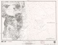
English: Scale 1:80,000. Facsim. of nautical chart originally published in 1881. Relief shown by hachures. Depths shown by contours and soundings. "American Revolution Bicentennial, 1776-1976." "Plate no. 1592." "BiC-37." Includes notes. Available also through the Library of Congress Web site as a raster image. AACR2 |
||
| Title | From New Inlet to Absecon Inlet. | ||
| Shelf ID | G3812.C6P5 1881 .U5 1976 | ||
| Date | |||
| Source | https://www.loc.gov/item/79695319/ | ||
| Author | [U.S. Coast And Geodetic Survey]; National Ocean Survey | ||
| Permission (Reusing this file) |
|
||
| Other versions |
|
||
| Location | New Jersey · United States | ||
| Part of | American Memory · General Maps · Catalog · Geography And Map Division | ||
| Subject | New Jersey · United States · Coasts · Nautical Charts · Facsimiles |

Licensing
edit
| This work is from the Library of Congress. According to the library, there are no known copyright restrictions on the use of this work. |  |
File history
Click on a date/time to view the file as it appeared at that time.
| Date/Time | Thumbnail | Dimensions | User | Comment | |
|---|---|---|---|---|---|
| current | 06:08, 2 June 2018 | | 5,161 × 4,070 (3.19 MB) | Fæ (talk | contribs) | LOC Maps https://www.loc.gov/item/79695319/ #2116 |
You cannot overwrite this file.
File usage on Commons
The following page uses this file: