File:Galveston, Texas, showing the fortifications etc. LOC 86691333.jpg

Size of this preview: 794 × 599 pixels. Other resolutions: 318 × 240 pixels | 636 × 480 pixels | 1,017 × 768 pixels | 1,280 × 966 pixels | 2,560 × 1,933 pixels | 5,897 × 4,452 pixels.
Original file (5,897 × 4,452 pixels, file size: 2.58 MB, MIME type: image/jpeg)
Captions
Captions
Add a one-line explanation of what this file represents
Summary edit
| Description |
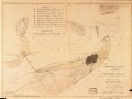
English: Covers Galveston area, west to southeast, from Swan Lake to Gulf of Mexico, and north to Bolivar Point. At head of title: Map no. 3. From the Nathaniel Prentice Banks papers in LC Manuscript Division. "Authorities: Coast Survey charts ... 1862." Sun print. LC Civil War maps (2nd ed.) 447.2 Available also through the Library of Congress Web site as a raster image. Acquisitions control no. 2-83 2 copies |
||
| Title | Galveston, Texas, showing the fortifications &c. | ||
| Shelf ID | G4034.G3S5 1862 .A2 | ||
| Date | |||
| Source | https://www.loc.gov/item/86691333/ | ||
| Author | Abbot, Henry L.; Banks, Nathaniel Prentiss; United States. Army. Department Of The Gulf; Brown & Ogilvie | ||
| Permission (Reusing this file) |
|
||
| Other versions |
|
||
| Location | United States · Galveston Region · Texas | ||
| Part of | Military Battles And Campaigns · American Memory · Civil War Maps · Catalog · Geography And Map Division | ||
| Subject | Galveston Region (Tex.) · Civil War · United States · Maps · Galveston Region · Texas · History |

Licensing edit
|
This is a faithful photographic reproduction of a two-dimensional, public domain work of art. The work of art itself is in the public domain for the following reason:
The official position taken by the Wikimedia Foundation is that "faithful reproductions of two-dimensional public domain works of art are public domain".
This photographic reproduction is therefore also considered to be in the public domain in the United States. In other jurisdictions, re-use of this content may be restricted; see Reuse of PD-Art photographs for details. | ||||
File history
Click on a date/time to view the file as it appeared at that time.
| Date/Time | Thumbnail | Dimensions | User | Comment | |
|---|---|---|---|---|---|
| current | 22:48, 3 June 2018 | | 5,897 × 4,452 (2.58 MB) | Fæ (talk | contribs) | LOC Maps https://www.loc.gov/item/86691333/ #19237 |
You cannot overwrite this file.
File usage on Commons
The following page uses this file: