File:Gas-pump island at Phin-Deli in the tourist-attraction town of Buford in rural Albany County, Wyoming LCCN2015632871.tif

Size of this JPG preview of this TIF file: 800 × 534 pixels. Other resolutions: 320 × 214 pixels | 640 × 427 pixels | 1,024 × 683 pixels | 1,280 × 854 pixels | 2,560 × 1,709 pixels | 7,360 × 4,912 pixels.
Original file (7,360 × 4,912 pixels, file size: 206.9 MB, MIME type: image/tiff)
Captions
Captions
Add a one-line explanation of what this file represents
Summary edit
| Description |
English: Title: Gas-pump island at Phin-Deli in the tourist-attraction town of Buford in rural Albany County, Wyoming
Physical description: 1 photograph : digital, tiff file, color. Notes: Forms part of: Gates Frontiers Fund Wyoming Collection within the Carol M. Highsmith Archive.; Credit line: Gates Frontiers Fund Wyoming Collection within the Carol M. Highsmith Archive, Library of Congress, Prints and Photographs Division.; Title, date and keywords based on information provided by the photographer.; Purchase; Carol M. Highsmith Photography, Inc.; 2015; (DLC/PP-2015:069).; This desolate place is an attraction that draws visitors off passing Interstate Highway 80 because of the town's official population: 1. Beginning in 1984, the "1" was Don Sammons, who lived there and ran the town's convenience store after every other resident moved away. Buford, named for Union major general John Buford during the U.S. Civil War, had 2,000 residents during the building of the transcontinental railroad through town in the 1860s. In 2013, the town was sold to a Vietnamese owner, who re-branded it as "PhinDeli Town Buford"; but the postal addresses still bear the town's original name. |
||||||||||||||||||||||||||
| Date | Taken on 7 June 2015, 15:03 (according to Exif data) | ||||||||||||||||||||||||||
| Source |
Library of Congress
|
||||||||||||||||||||||||||
| Author |
|
||||||||||||||||||||||||||
| Permission (Reusing this file) |
No known restrictions on publication.
|
||||||||||||||||||||||||||


| Camera location | | View this and other nearby images on: OpenStreetMap |
|---|
Licensing edit
| This work is from the Carol M. Highsmith Archive collection at the Library of Congress. According to the library, there are no known copyright restrictions on the use of this work. Carol M. Highsmith has stipulated that her photographs are in the public domain. Photographs of sculpture or other works of art may be restricted by the copyright of the artist; see Commons:FOP US#Artworks and sculptures for more information. |
 |
File history
Click on a date/time to view the file as it appeared at that time.
| Date/Time | Thumbnail | Dimensions | User | Comment | |
|---|---|---|---|---|---|
| current | 13:37, 30 September 2016 |  | 7,360 × 4,912 (206.9 MB) | Fæ (talk | contribs) | LOC 2015632871, Carol M. Highsmith collection. P74.23713 TIFF (206.9mb) |
| 13:37, 30 September 2016 | 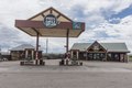 | 7,360 × 4,912 (206.9 MB) | Fæ (talk | contribs) | LOC 2015632871, Carol M. Highsmith collection. P74.23713 TIFF (206.9mb) |
You cannot overwrite this file.
File usage on Commons
There are no pages that use this file.