File:Gaza Strip. LOC 2005631037.jpg

Size of this preview: 560 × 600 pixels. Other resolutions: 224 × 240 pixels | 448 × 480 pixels | 717 × 768 pixels | 956 × 1,024 pixels | 1,913 × 2,048 pixels | 7,992 × 8,556 pixels.
Original file (7,992 × 8,556 pixels, file size: 10.1 MB, MIME type: image/jpeg)
Captions
Captions
Add a one-line explanation of what this file represents
Summary edit
| Description |
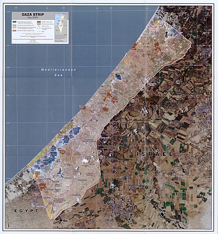
English: Includes inset location map and notes. "May 2005." "803130 (G00032) 5-05." Available also through the Library of Congress Web site as a raster image. |
||
| Title | Gaza Strip. | ||
| Shelf ID | G8302.G3A4 2005 .U5 | ||
| Date | |||
| Source | https://www.loc.gov/item/2005631037/ | ||
| Author | United States. Central Intelligence Agency | ||
| Permission (Reusing this file) |
|
||
| Other versions |
|
||
| Location | Gaza Strip | ||
| Part of | American Memory · Places In The News Archive · Catalog · Geography And Map Division · General Maps | ||
| Subject | Gaza Strip · Remote-Sensing Maps |


Licensing edit
| This image is a work of a Central Intelligence Agency employee, taken or made as part of that person's official duties. As a Work of the United States Government, this image or media is in the public domain in the United States.
|

|
File history
Click on a date/time to view the file as it appeared at that time.
| Date/Time | Thumbnail | Dimensions | User | Comment | |
|---|---|---|---|---|---|
| current | 20:01, 20 June 2018 | | 7,992 × 8,556 (10.1 MB) | Fæ (talk | contribs) | LOC Maps https://www.loc.gov/item/2005631037/ #22397 |
You cannot overwrite this file.
File usage on Commons
The following page uses this file: