File:Generalʹnai︠a︡ Karta Tavricheskoĭ Gubernii Sʺ pokazaniemʺ pochtovykhʺ i bolʹshikhʺ proi︠e︡zzhikhʺ dorogʺ, stant︠s︡iĭ i razstoi︠a︡nii︠a︡ mezhdu onymi verstʺ. LOC 2018688660.tif

Size of this JPG preview of this TIF file: 714 × 600 pixels. Other resolutions: 286 × 240 pixels | 571 × 480 pixels | 914 × 768 pixels | 1,219 × 1,024 pixels | 2,438 × 2,048 pixels | 5,780 × 4,856 pixels.
Original file (5,780 × 4,856 pixels, file size: 80.3 MB, MIME type: image/tiff)
Captions
Captions
Add a one-line explanation of what this file represents
Summary
edit| Description |
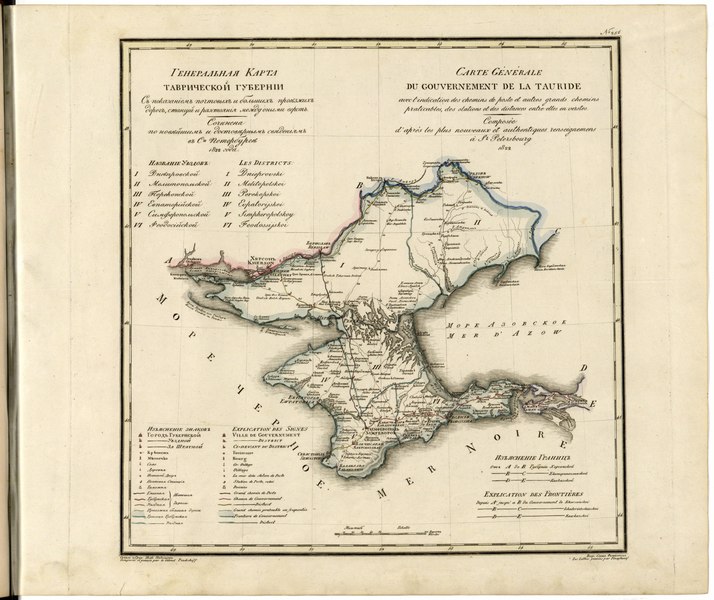
English: This 1822 map ofTaurida Provinceis from a larger work,Geograficheskii atlas Rossiiskoi imperii, tsarstva Pol'skogo i velikogo kniazhestva Finliandskogo(Geographical atlas of the Russian Empire, the Kingdom of Poland, and the Grand Duchy of Finland), containing 60 maps of the Russian Empire. Compiled and engraved by Colonel V.P. Piadyshev, it reflects the detailed mapping carried out by Russian military cartographers in the first quarter of the 19th century. The map shows population centers (six gradations by size), postal stations, roads (four types), provincial and district borders, customs houses, and forts. Distances are shown in versts, a Russian measure, now no longer used, equal to 1.07 kilometers.Legends, the index of county names, and place-names are in Russian and French. This region experienced numerous invasions and migrations since Antiquity, by peoples who included Scythians, Sarmatians, and Goths. Most prominently, Greek and Roman settlements were established on the Crimean Peninsula. Later invaders included the Byzantine Empire, Kievan Rus', the Golden Horde (and its successor state, the Crimean Khanate), and Ottoman Turkey. Orthodox Christianity may have gained a foothold in the lands of Rus' through Crimea from Constantinople by the 9th to 10th centuries. Empress Catherine the Great later conquered this region from Ottoman Turkey, incorporating Crimea into the Russian Empire in 1783, along with adjoining parts of what became known as Novorossiya (New Russia). One of her key advisers and favorites, Prince Grigorii Potemkin, was named the governor-general of this larger region in 1774. World Digital Library. |
||
| Title | Generalʹnai︠a︡ Karta Tavricheskoĭ Gubernii Sʺ pokazaniemʺ pochtovykhʺ i bolʹshikhʺ proi︠e︡zzhikhʺ dorogʺ, stant︠s︡iĭ i razstoi︠a︡nii︠a︡ mezhdu onymi verstʺ. | ||
| Shelf ID | http://lccn.loc.gov/2018688660 | ||
| Date | |||
| Source | https://www.loc.gov/item/2018688660/ | ||
| Author | Pi︠A︡Dyshev, Vasiliĭ Petrovich; Russia. General Staff. Military Topographical Depot; Finaghenof | ||
| Permission (Reusing this file) |
|
||
| Other versions |
|
||
| Location | Russian Federation · Ukraine | ||
| Part of | Geographical Atlas Of The Russian Empire, The Kingdom Of Poland, And The Grand Duchy Of Finland · Catalog · National Library Of Russia · Meeting Of Frontiers | ||
| Subject | Russian Federation · Maps · Atlases · Ukraine · Siberia |


Licensing
edit|
This is a faithful photographic reproduction of a two-dimensional, public domain work of art. The work of art itself is in the public domain for the following reason:
The official position taken by the Wikimedia Foundation is that "faithful reproductions of two-dimensional public domain works of art are public domain".
This photographic reproduction is therefore also considered to be in the public domain in the United States. In other jurisdictions, re-use of this content may be restricted; see Reuse of PD-Art photographs for details. | ||||
File history
Click on a date/time to view the file as it appeared at that time.
| Date/Time | Thumbnail | Dimensions | User | Comment | |
|---|---|---|---|---|---|
| current | 16:02, 5 March 2020 |  | 5,780 × 4,856 (80.3 MB) | Fæ (talk | contribs) | LOC Maps https://www.loc.gov/item/2018688660/ #13881 |
You cannot overwrite this file.
File usage on Commons
There are no pages that use this file.