File:General soil map, Lincoln Parish, Louisiana LOC 92682547.jpg

Size of this preview: 411 × 600 pixels. Other resolutions: 164 × 240 pixels | 329 × 480 pixels | 526 × 768 pixels | 702 × 1,024 pixels | 1,404 × 2,048 pixels | 6,313 × 9,210 pixels.
Original file (6,313 × 9,210 pixels, file size: 4.72 MB, MIME type: image/jpeg)
Captions
Captions
Add a one-line explanation of what this file represents
Summary
edit| Description |
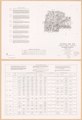
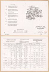
English: In lower right margin: Revised Nov. 1971. 4-R-17131-A. "Compiled from Base 4-R-28702." Includes descriptive legend and table "Proportion of association in parish." Text and table "Soil interpretations for selected uses" on verso. Available also through the Library of Congress Web site as a raster image. |
||
| Title | General soil map, Lincoln Parish, Louisiana | ||
| Shelf ID | G4013.L5J3 1971 .U5 | ||
| Date | |||
| Source | https://www.loc.gov/item/92682547/ | ||
| Author | United States. Soil Conservation Service; Louisiana Agricultural Experiment Station; National Cartographic Center (U.S.) | ||
| Permission (Reusing this file) |
|
||
| Other versions |
|
||
| Location | United States · Lincoln Parish. · Louisiana · Lincoln Parish | ||
| Part of | American Memory · Catalog · Geography And Map Division · Additional Conservation And Environment Cartographic Items | ||
| Subject | United States · Soils · Louisiana · Lincoln Parish · Maps |

Licensing
edit
| This work is from the Library of Congress. According to the library, there are no known copyright restrictions on the use of this work. |  |
File history
Click on a date/time to view the file as it appeared at that time.
| Date/Time | Thumbnail | Dimensions | User | Comment | |
|---|---|---|---|---|---|
| current | 05:25, 26 June 2019 | | 6,313 × 9,210 (4.72 MB) | Fæ (talk | contribs) | LOC Maps https://www.loc.gov/item/92682547/ #16219 |
You cannot overwrite this file.
File usage on Commons
The following page uses this file: