File:Georgia, Dalton sheet LOC 2007626717.jpg
Size of this preview: 494 × 600 pixels. Other resolutions: 198 × 240 pixels | 395 × 480 pixels | 632 × 768 pixels | 843 × 1,024 pixels | 1,687 × 2,048 pixels | 4,836 × 5,872 pixels.
Original file (4,836 × 5,872 pixels, file size: 3.72 MB, MIME type: image/jpeg)
Captions
Captions
Add a one-line explanation of what this file represents
Summary
edit| Description |
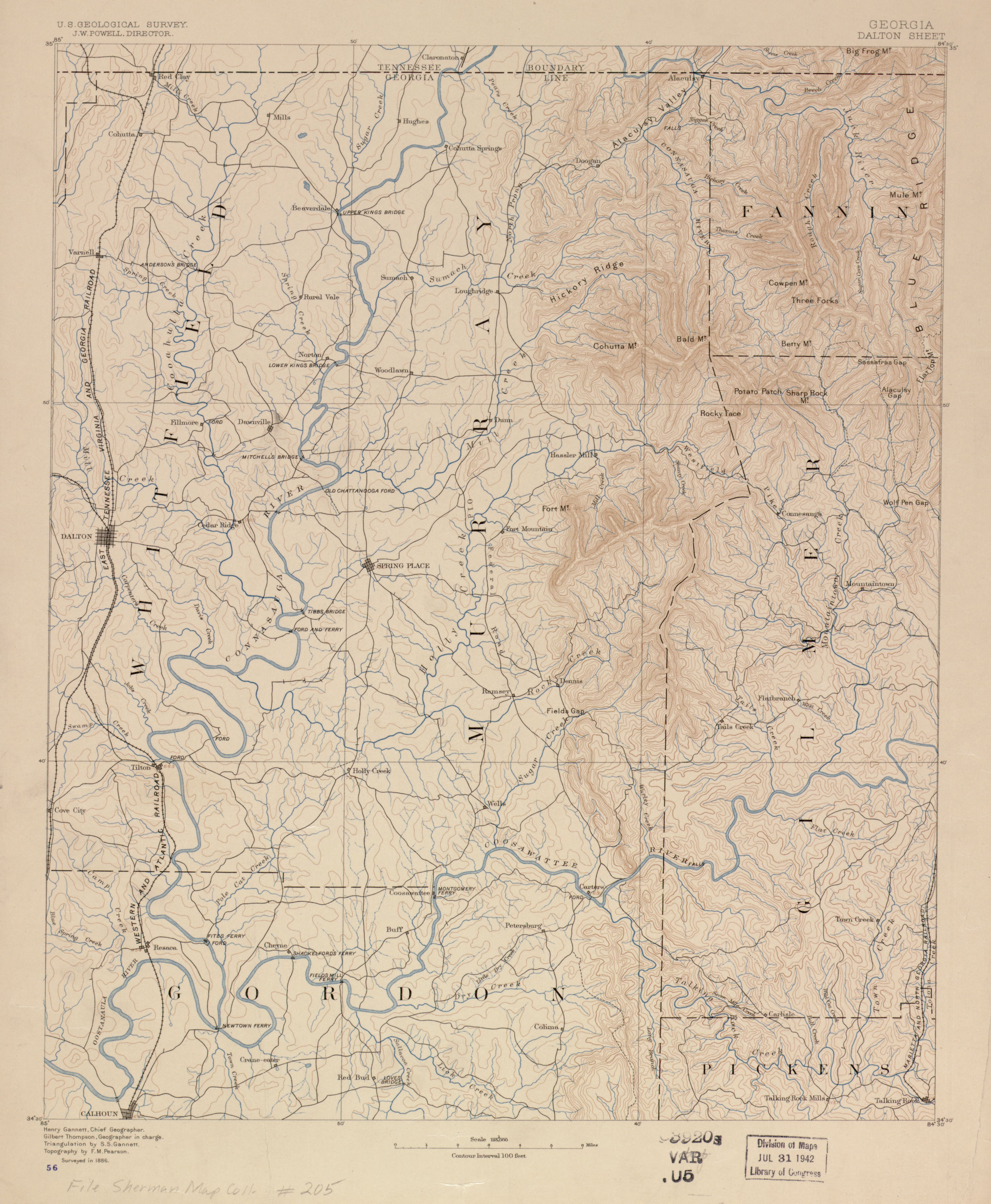
English: Relief shown by contours and spot heights. LC Civil War maps (2nd ed.), S205 Available also through the Library of Congress Web site as a raster image. "Surveyed in 1886." Stamped in blue ink at lower left: 56. Stamped in black ink in lower right margin: G3920 svar .U5. LC copy imperfect: Mounted on cloth, laminated. |
||
| Title | Georgia, Dalton sheet | ||
| Shelf ID | G3924.D2A1 1886 .G4 | ||
| Date | |||
| Source | https://www.loc.gov/item/2007626717/ | ||
| Author | Geological Survey (U.S.); Gannett, Henry; Thompson, Gilbert; Gannett, Samuel S. (Samuel Stinson); Pearson, F. M. | ||
| Permission (Reusing this file) |
|
||
| Other versions |
|
||
| Location | United States · Whitfield County · Dalton Region · Georgia | ||
| Part of | Military Battles And Campaigns · American Memory · Civil War Maps · Catalog · Geography And Map Division | ||
| Subject | Georgia · Topographic Maps · United States · Maps · Dalton Region · Dalton Region (Whitfield County, Ga.) |

Licensing
edit
|
This is a faithful photographic reproduction of a two-dimensional, public domain work of art. The work of art itself is in the public domain for the following reason:
The official position taken by the Wikimedia Foundation is that "faithful reproductions of two-dimensional public domain works of art are public domain".
This photographic reproduction is therefore also considered to be in the public domain in the United States. In other jurisdictions, re-use of this content may be restricted; see Reuse of PD-Art photographs for details. | ||||
File history
Click on a date/time to view the file as it appeared at that time.
| Date/Time | Thumbnail | Dimensions | User | Comment | |
|---|---|---|---|---|---|
| current | 17:21, 24 May 2018 | | 4,836 × 5,872 (3.72 MB) | Fæ (talk | contribs) | LOC Maps https://www.loc.gov/item/2007626717/ #363 |
You cannot overwrite this file.
File usage on Commons
The following page uses this file: