File:Gettysburg National Military Park, Pennsylvania, official map and guide LOC 94684170.tif

Size of this JPG preview of this TIF file: 800 × 374 pixels. Other resolutions: 320 × 150 pixels | 640 × 299 pixels | 1,024 × 479 pixels | 1,280 × 598 pixels | 2,560 × 1,196 pixels | 10,115 × 4,727 pixels.
Original file (10,115 × 4,727 pixels, file size: 136.8 MB, MIME type: image/tiff)
Captions
Captions
Add a one-line explanation of what this file represents
Summary
edit| Description |
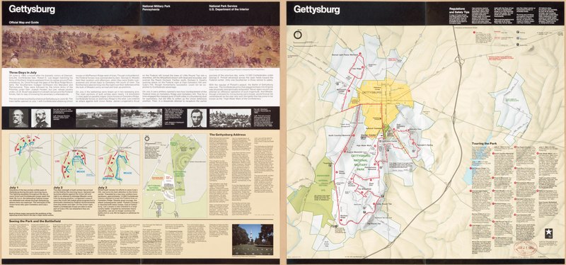
English: Some issues have: *GPO: 1994--301-085/80183. Reprint 1994; others have: *GPO: 1994--301-085/00046. Reprint 1994. Relief shown by shading. Panel title. Title in upper margin: Gettysburg. Includes text and descriptive index to points of interest. Text, map of headquarters vicinity, 3 troop-position maps, and ill. (some col.) on verso. Available also through the Library of Congress Web site as a raster image. |
||
| Title | Gettysburg National Military Park, Pennsylvania, official map and guide | ||
| Shelf ID | G3822.G4 1994 .U5 | ||
| Date | |||
| Source | https://www.loc.gov/item/94684170/ | ||
| Author | United States. National Park Service | ||
| Permission (Reusing this file) |
|
||
| Other versions |
|
||
| Location | Gettysburg National Military Park. · Pennsylvania · Gettysburg Region. · United States · Gettysburg National Military Park · Gettysburg Region | ||
| Part of | American Memory · General Maps · Catalog · Geography And Map Division | ||
| Subject | Gettysburg Region (Pa.) · Pennsylvania · Gettysburg National Military Park (Pa.) · Gettysburg National Military Park · United States · Maps · Tours · Gettysburg Region |


Licensing
edit| This image or media file contains material based on a work of a National Park Service employee, created as part of that person's official duties. As a work of the U.S. federal government, such work is in the public domain in the United States. See the NPS website and NPS copyright policy for more information. |
File history
Click on a date/time to view the file as it appeared at that time.
| Date/Time | Thumbnail | Dimensions | User | Comment | |
|---|---|---|---|---|---|
| current | 19:33, 9 May 2018 |  | 10,115 × 4,727 (136.8 MB) | Fæ (talk | contribs) | LOC Maps https://www.loc.gov/item/94684170/ #5017 |
You cannot overwrite this file.
File usage on Commons
The following page uses this file: