File:Governors Island National Monument, New York LOC 2010588359.jpg

Size of this preview: 647 × 600 pixels. Other resolutions: 259 × 240 pixels | 518 × 480 pixels | 829 × 768 pixels | 1,105 × 1,024 pixels | 2,210 × 2,048 pixels | 5,246 × 4,861 pixels.
Original file (5,246 × 4,861 pixels, file size: 3.73 MB, MIME type: image/jpeg)
Captions
Captions
Add a one-line explanation of what this file represents
Summary edit
| Description |
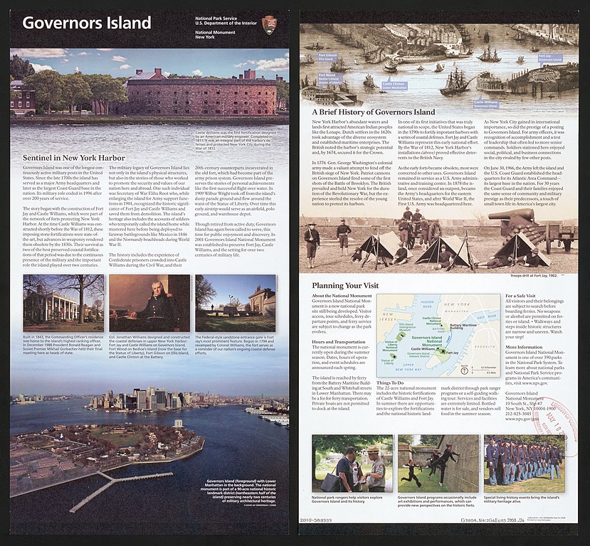
English: Island map is a regional location map showing showing the positions of other federally administered park properties in Upper New York Bay. "*GPO:2010--357-940/80446 Reprint 2008." Title from panel. Includes text and ill. (some col.). Available also through the Library of Congress Web site as a raster image. |
||
| Title | Governors Island National Monument, New York | ||
| Shelf ID | G3804.N4:2G6E635 2008 .U6 | ||
| Date | |||
| Source | https://www.loc.gov/item/2010588359/ | ||
| Author | United States. National Park Service | ||
| Permission (Reusing this file) |
|
||
| Other versions |
|
||
| Location | Governors Island · United States · New York · New York County · New York. · Governors Island Region · New York (State) | ||
| Part of | American Memory · General Maps · Catalog · Geography And Map Division | ||
| Subject | Aerial Views · Historic Sites · Governors Island (New York County, N.Y.) · Governors Island · Tourist Maps · United States · Maps · New York · Governors Island Region (New York County, N.Y.) · Governors Island Region · New York County · National Parks And Reserves · New York (State) |

Licensing edit
| This image or media file contains material based on a work of a National Park Service employee, created as part of that person's official duties. As a work of the U.S. federal government, such work is in the public domain in the United States. See the NPS website and NPS copyright policy for more information. |
File history
Click on a date/time to view the file as it appeared at that time.
| Date/Time | Thumbnail | Dimensions | User | Comment | |
|---|---|---|---|---|---|
| current | 15:58, 8 June 2018 | | 5,246 × 4,861 (3.73 MB) | Fæ (talk | contribs) | LOC Maps https://www.loc.gov/item/2010588359/ #8850 |
You cannot overwrite this file.
File usage on Commons
The following page uses this file: