File:Map of Armenian S.S.R. 1932.jpg

Size of this preview: 581 × 599 pixels. Other resolutions: 233 × 240 pixels | 465 × 480 pixels | 745 × 768 pixels | 993 × 1,024 pixels | 1,986 × 2,048 pixels | 18,434 × 19,008 pixels.
Original file (18,434 × 19,008 pixels, file size: 57.93 MB, MIME type: image/jpeg)
Captions
Captions
Add a one-line explanation of what this file represents
Summary edit
| Warning | The original file is very high-resolution. It might not load properly or could cause your browser to freeze when opened at full size. |
|---|
| Description |
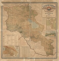
English: Wall map originally issued with rods at top and bottom to facilitate hanging/rolling. Relief shown by shading and spot heights. Depths shown by contours and gradient tints. Gift; Roger and Julie Kulhanjian Strauch (Madison Council); October 2014. Printed in NW/NE/SW/SE segments (sheets). LC copy imperfect: Brittle, darkened, rubber-stamped, upper left corner of map torn away, mounted on cloth backing. Includes notes, statistical table for counties of the Armenian S.S.R., inset of Yerevan city (with index to points-of-interest), inset of the South Caucasus republics (with statistical table), color illustrations of mountain heights (with graph), and Armenia coat-of-arms. Available also through the Library of Congress Web site as a raster image. Vault |
||
| Title | Hayastani Sotsʻialistakan Khorhdayin Hanrapetutʻyan kartēz | ||
| Shelf ID | G7150 1932 .A9 | ||
| Date | |||
| Source | https://www.loc.gov/item/2014585716/ | ||
| Author | Avdalbegyan, Kh. | ||
| Permission (Reusing this file) |
|
||
| Location | Caucasus, South · Armenia (Republic) · South Caucasus · Republic · Armenia · Yerevan | ||
| Part of | American Memory · General Maps · Catalog · Geography And Map Division | ||
| Subject | Caucasus, South · Armenia (Republic) · Maps · Armenia · Wall Maps · Yerevan (Armenia) · Yerevan |

Licensing edit
|
This is a faithful photographic reproduction of a two-dimensional, public domain work of art. The work of art itself is in the public domain for the following reason:
The official position taken by the Wikimedia Foundation is that "faithful reproductions of two-dimensional public domain works of art are public domain".
This photographic reproduction is therefore also considered to be in the public domain in the United States. In other jurisdictions, re-use of this content may be restricted; see Reuse of PD-Art photographs for details. | ||||
File history
Click on a date/time to view the file as it appeared at that time.
| Date/Time | Thumbnail | Dimensions | User | Comment | |
|---|---|---|---|---|---|
| current | 14:37, 9 June 2018 | | 18,434 × 19,008 (57.93 MB) | Fæ (talk | contribs) | LOC Maps https://www.loc.gov/item/2014585716/ #24824 |
You cannot overwrite this file.
File usage on Commons
The following page uses this file:
File usage on other wikis
The following other wikis use this file:
- Usage on ru.wikipedia.org