File:Honduras. LOC 84694131.tif

Size of this JPG preview of this TIF file: 800 × 535 pixels. Other resolutions: 320 × 214 pixels | 640 × 428 pixels | 1,024 × 685 pixels | 1,280 × 856 pixels | 2,560 × 1,713 pixels | 9,496 × 6,354 pixels.
Original file (9,496 × 6,354 pixels, file size: 172.63 MB, MIME type: image/tiff)
Captions
Captions
Add a one-line explanation of what this file represents
Summary
edit| Description |
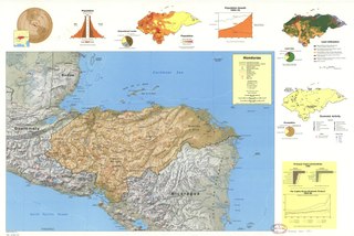
English: Relief shown by shading and spot heights. Depths shown by contours. "504929 (547282) 8-83." Available also through the Library of Congress Web site as a raster image. Includes location map with radial distance, comparative area map, subject maps of "Population," "Land utilization," and "Economic activity," and graphs of "Population," "Educational levels," "Population growth 1925-75," "Land use," "Occupation," "Principal trade commodities 1980," and "Per capita gross domestic product 1945-80." DRM |
||
| Title | Honduras. | ||
| Shelf ID | G4830 1983 .U51 | ||
| Date | |||
| Source | https://www.loc.gov/item/84694131/ | ||
| Author | United States. Central Intelligence Agency | ||
| Permission (Reusing this file) |
|
||
| Other versions |
|
||
| Location | Honduras | ||
| Part of | American Memory · General Maps · Catalog · Geography And Map Division | ||
| Subject | Maps · Land Use · Economic Conditions · Honduras · Population |


Licensing
edit| This image is a work of a Central Intelligence Agency employee, taken or made as part of that person's official duties. As a Work of the United States Government, this image or media is in the public domain in the United States.
|

|
File history
Click on a date/time to view the file as it appeared at that time.
| Date/Time | Thumbnail | Dimensions | User | Comment | |
|---|---|---|---|---|---|
| current | 16:05, 11 June 2018 |  | 9,496 × 6,354 (172.63 MB) | Fæ (talk | contribs) | LOC Maps https://www.loc.gov/item/84694131/ #26980 |
You cannot overwrite this file.
File usage on Commons
The following page uses this file: