File:Indian reservations west of the Mississippi River LOC 2008622187.jpg

Size of this preview: 800 × 540 pixels. Other resolutions: 320 × 216 pixels | 640 × 432 pixels | 1,024 × 691 pixels | 1,280 × 864 pixels | 2,560 × 1,727 pixels | 11,838 × 7,987 pixels.
Original file (11,838 × 7,987 pixels, file size: 10.46 MB, MIME type: image/jpeg)
Captions
Captions
Add a one-line explanation of what this file represents
Summary edit
| Warning | The original file is very high-resolution. It might not load properly or could cause your browser to freeze when opened at full size. |
|---|
| Description |
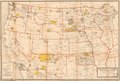
English: Relief shown by hachures. "Base map furnished by General Land Office." From the U.S. Office of Indian Affairs' Annual report of the Commissioner of Indian Affairs to the Secretary of the Interior. Washington, D.C., 1920-43. Includes railroads. LC copy imperfect: Map torn at lower left corner. Available also through the Library of Congress Web site as a raster image. |
||
| Title | Indian reservations west of the Mississippi River | ||
| Shelf ID | G4051.G6 1923 .U5 | ||
| Date | |||
| Source | https://www.loc.gov/item/2008622187/ | ||
| Author | Geological Survey (U.S.); United States. Office Of Indian Affairs | ||
| Permission (Reusing this file) |
|
||
| Other versions |
|
||
| Location | United States · West · West. | ||
| Part of | American Memory · General Maps · Catalog · Geography And Map Division | ||
| Subject | Indian Reservations · West · Railroads · West (U.S.) · United States · Maps |

Licensing edit
|
This is a faithful photographic reproduction of a two-dimensional, public domain work of art. The work of art itself is in the public domain for the following reason:
The official position taken by the Wikimedia Foundation is that "faithful reproductions of two-dimensional public domain works of art are public domain".
This photographic reproduction is therefore also considered to be in the public domain in the United States. In other jurisdictions, re-use of this content may be restricted; see Reuse of PD-Art photographs for details. | ||||
File history
Click on a date/time to view the file as it appeared at that time.
| Date/Time | Thumbnail | Dimensions | User | Comment | |
|---|---|---|---|---|---|
| current | 08:14, 13 March 2020 | | 11,838 × 7,987 (10.46 MB) | Fæ (talk | contribs) | LOC Maps https://www.loc.gov/item/2008622187/ #12571 |
You cannot overwrite this file.
File usage on Commons
The following page uses this file: