File:Iran country profile. LOC 2009583341.tif
Size of this JPG preview of this TIF file: 800 × 524 pixels. Other resolutions: 320 × 209 pixels | 640 × 419 pixels | 1,024 × 670 pixels | 1,280 × 838 pixels | 2,560 × 1,675 pixels | 15,561 × 10,184 pixels.
Original file (15,561 × 10,184 pixels, file size: 453.4 MB, MIME type: image/tiff)
Captions
Captions
Add a one-line explanation of what this file represents
Summary edit
| Warning | The original file is very high-resolution. It might not load properly or could cause your browser to freeze when opened at full size. |
|---|
| Description |
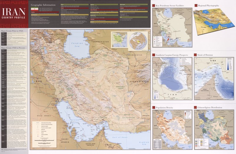
English: Relief shown by shading. Available also through the Library of Congress Web site as a raster image. "78803AI (C00708) 10-09." "435852ID 10-09." Includes text, comparative area map, location map, and list of major historical events since 1908. Ancillary maps: Key petroleum sector facilities -- Regional physiography -- Southern Caspian energy prospects -- Strait of Hormuz -- Population density -- Ethnoreligious distribution. |
||
| Title | Iran country profile. | ||
| Shelf ID | G7620 2009 .U5 | ||
| Date | |||
| Source | https://www.loc.gov/item/2009583341/ | ||
| Author | United States. Central Intelligence Agency. Cartography Center | ||
| Permission (Reusing this file) |
|
||
| Other versions |
|
||
| Location | Iran | ||
| Part of | American Memory · General Maps · Catalog · Geography And Map Division | ||
| Subject | Iran · Religion · Physical Geography · Petroleum · Maps · Population Density · Ethnic Groups |


Licensing edit
| This image is a work of a Central Intelligence Agency employee, taken or made as part of that person's official duties. As a Work of the United States Government, this image or media is in the public domain in the United States.
|

|
File history
Click on a date/time to view the file as it appeared at that time.
| Date/Time | Thumbnail | Dimensions | User | Comment | |
|---|---|---|---|---|---|
| current | 16:01, 7 June 2018 |  | 15,561 × 10,184 (453.4 MB) | Fæ (talk | contribs) | LOC Maps https://www.loc.gov/item/2009583341/ #22879 |
You cannot overwrite this file.
File usage on Commons
The following page uses this file: