File:Johnson's Virginia, Delaware, Maryland & West Virginia LOC lva0000026.jpg

Size of this preview: 800 × 538 pixels. Other resolutions: 320 × 215 pixels | 640 × 430 pixels | 1,024 × 689 pixels | 1,280 × 861 pixels | 2,560 × 1,722 pixels | 9,752 × 6,559 pixels.
Original file (9,752 × 6,559 pixels, file size: 14.05 MB, MIME type: image/jpeg)
Captions
Captions
Add a one-line explanation of what this file represents
Summary edit
| Description |
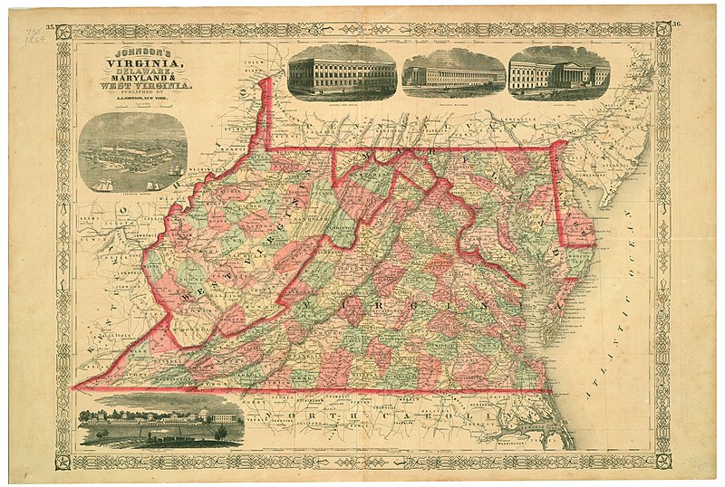
English: "Entered according to Act of Congress in the year 1864, by A.J. Johnson, in the Clerk's Office of the District Court of the United States for the Southern District of New York." Includes ill. of "Fortress Monroe," "General post office," "Treasury buildings," "Patent Office," and "University of Virginia." Plates 35-36. Relief shown by hachures. Depths shown by isolines. Shows counties, railroads, and includes some counties of West Virginia, created in 1863. This item is in the Map Collection of the Library of Virginia; please contact the Library's Archives Research Services department for more information. Available also through the Library of Congress web site as raster image. Jan. 2002, Book and Print Shop, Hanover, N.H., d, ALE. |
||
| Title | Johnson's Virginia, Delaware, Maryland & West Virginia | ||
| Shelf ID | https://www.loc.gov/item/lva0000026/ | ||
| Date | |||
| Source | https://www.loc.gov/item/lva0000026/ | ||
| Author | Johnson, A. J. (Alvin Jewett) | ||
| Permission (Reusing this file) |
|
||
| Other versions |
|
||
| Location | Delaware · Virginia · United States · Middle Atlantic States · West Virginia · Maryland | ||
| Part of | Military Battles And Campaigns · American Memory · Civil War Maps · Geography And Map Division | ||
| Subject | Delaware · Virginia · Civil War · United States · Maps · Middle Atlantic States · West Virginia · Maryland · History |


Licensing edit
|
This is a faithful photographic reproduction of a two-dimensional, public domain work of art. The work of art itself is in the public domain for the following reason:
The official position taken by the Wikimedia Foundation is that "faithful reproductions of two-dimensional public domain works of art are public domain".
This photographic reproduction is therefore also considered to be in the public domain in the United States. In other jurisdictions, re-use of this content may be restricted; see Reuse of PD-Art photographs for details. | ||||
File history
Click on a date/time to view the file as it appeared at that time.
| Date/Time | Thumbnail | Dimensions | User | Comment | |
|---|---|---|---|---|---|
| current | 13:45, 26 May 2018 | | 9,752 × 6,559 (14.05 MB) | Fæ (talk | contribs) | LOC Maps https://www.loc.gov/item/lva0000026/ #1853 |
You cannot overwrite this file.
File usage on Commons
The following page uses this file: