File:Karta ispravitel'no-trudovykh lagereĭ, nakhodivshikhsi︠a︡ na territorii tresta "Dal'stroĭ" (nyne Magadanskai︠a︡ oblast') v 1930-1950 godakh. LOC 2018688076.jpg

Size of this preview: 668 × 599 pixels. Other resolutions: 268 × 240 pixels | 535 × 480 pixels | 856 × 768 pixels | 1,141 × 1,024 pixels | 2,282 × 2,048 pixels | 3,009 × 2,700 pixels.
Original file (3,009 × 2,700 pixels, file size: 1.57 MB, MIME type: image/jpeg)
Captions
Captions
Add a one-line explanation of what this file represents
Summary
edit| Description |
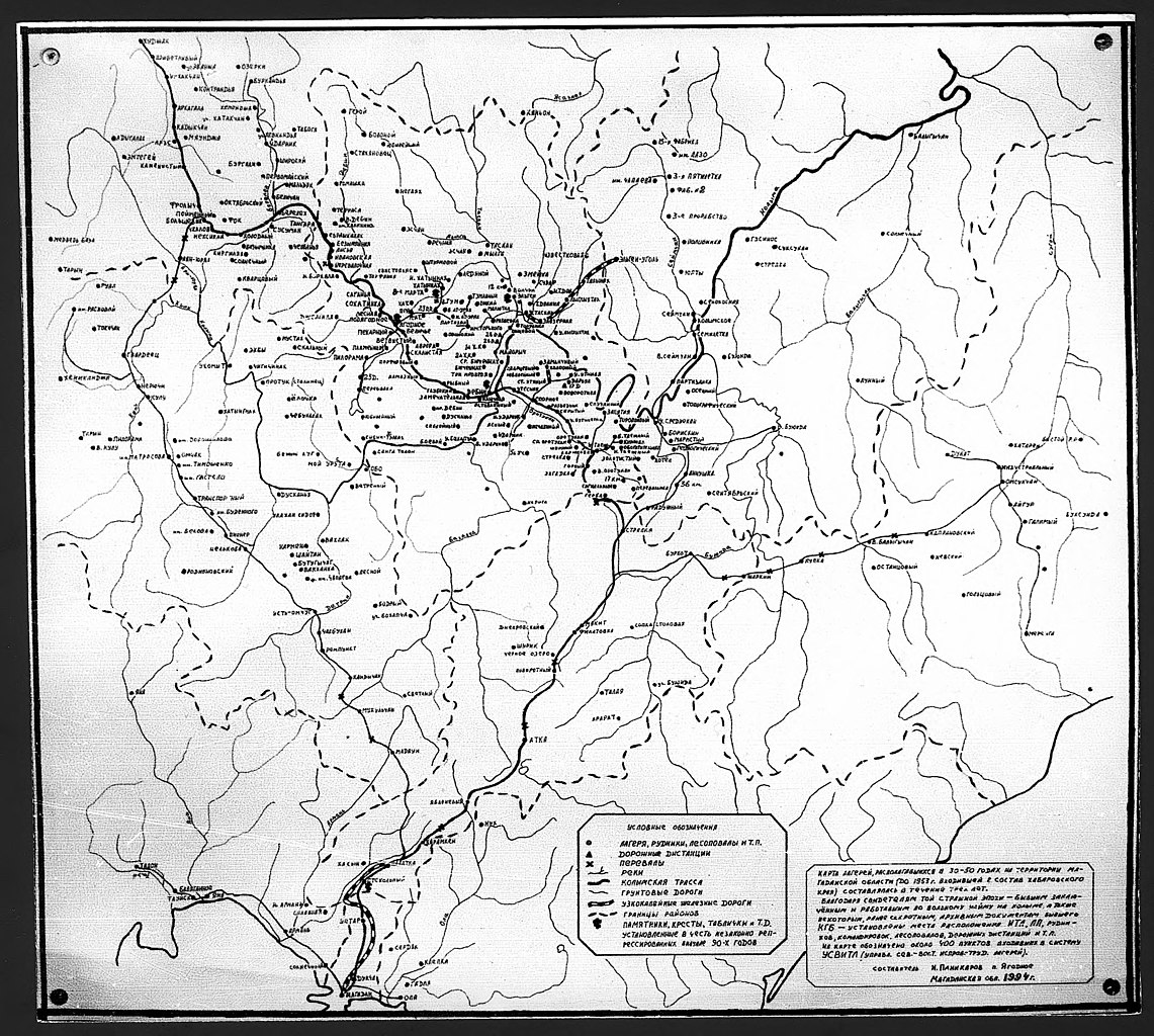
English: This item is from a collection of photographs, drawings, newspapers, and documents gathered in the Kolyma region of Russia. Kolyma is a northeastern region that takes its name from the Kolyma River and includes parts of the present-day Chukotka Autonomous Okrug and present-day Magadan Oblast. This region contained deposits of gold and platinum and was home to Sevvostlag (Northeastern Corrective Labor Camps), one of the Soviet Union's most infamous labor camp systems, which was administered by a government agency known as Dalstroy (Far North Construction Trust). These materials were collected by the Yagodnoye District public historical and educational organization "Search for the Unlawfully Repressed." This organization was founded in 1990 with the goal of locating former prisoners of the Kolyma camps. It corresponds with more than 500 former prisoners and their relatives, publishes prisoners' memoirs, conducts local history research, and carries out expeditions to the remains of camps. The materials collected by Search for the Unlawfully Repressed became the basis for the collections of the Memory of Kolyma Museum, where this collection is housed. The collection's photographs depict ruins of camp buildings, daily life in Kolyma, and journalists traveling in the region. Other materials of the collection include a map of Kolyma's camps, newspapers from the region, certificates, letters, records of criminal cases, and personal files. Parts of the collection were digitized in the early 2000s for the Meeting of Frontiers digital library project. World Digital Library. |
||
| Title | Karta ispravitel'no-trudovykh lagereĭ, nakhodivshikhsi︠a︡ na territorii tresta "Dal'stroĭ" (nyne Magadanskai︠a︡ oblast') v 1930-1950 godakh. | ||
| Shelf ID | http://lccn.loc.gov/2018688076 | ||
| Date | |||
| Source | https://www.loc.gov/item/2018688076/ | ||
| Author | Panikarov, Ivan Aleksandrovich | ||
| Permission (Reusing this file) |
|
||
| Other versions |
|
||
| Location | Russian Federation · Magadan Oblast · Yagodnoye | ||
| Part of | Meeting Of Frontiers · Catalog · Memory Of Kolyma Museum · Materials On The History Of Sevvostlag | ||
| Subject | Convict Labor · Labor Camps · Logging · Prisons · Lageri︠A · Mines And Mineral Resources · Magadan Oblast · Maps · Lesopovaly · Siberia · Yagodnoye · Roads · Rudniki · Dal'Lag · Dorogi · Magadan · Russian Federation · Russian Far East |


_v_1930-1950_godakh._LOC_2018688076.jpg&action=edit§ion=1)
Licensing
edit_v_1930-1950_godakh._LOC_2018688076.jpg&action=edit§ion=2)
| This work is from the Library of Congress. According to the library, there are no known copyright restrictions on the use of this work. |  |
File history
Click on a date/time to view the file as it appeared at that time.
| Date/Time | Thumbnail | Dimensions | User | Comment | |
|---|---|---|---|---|---|
| current | 00:18, 13 January 2020 | | 3,009 × 2,700 (1.57 MB) | Fæ (talk | contribs) | LOC Maps https://www.loc.gov/item/2018688076/ #5359 |
You cannot overwrite this file.
File usage on Commons
The following page uses this file:
_v_1930-1950_godakh._LOC_2018688076.jpg&oldid=747818702)