File:Kings Mountain, National Military Park, South Carolina LOC 2008621682.tif
Size of this JPG preview of this TIF file: 800 × 378 pixels. Other resolutions: 320 × 151 pixels | 640 × 303 pixels | 1,024 × 484 pixels | 1,280 × 605 pixels | 2,560 × 1,211 pixels | 10,217 × 4,833 pixels.
Original file (10,217 × 4,833 pixels, file size: 141.27 MB, MIME type: image/tiff)
Captions
Captions
Add a one-line explanation of what this file represents
Summary edit
| Description |
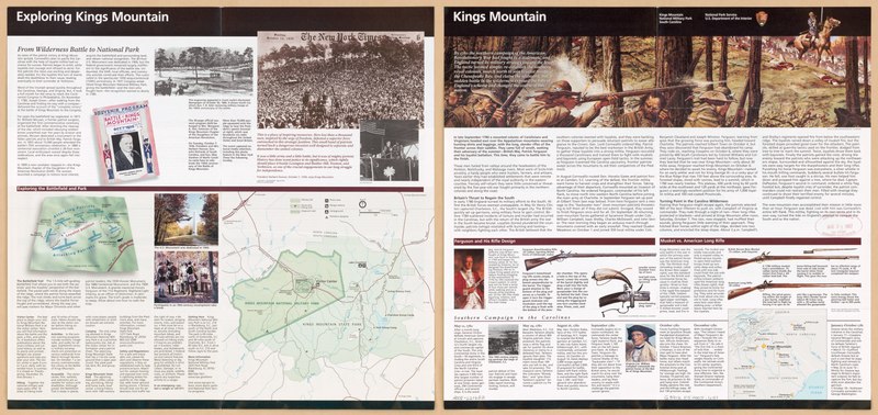
English: "*GPO: 2007--330-358/00692 Reprinted 2005." Title from panel. Includes text, ancillary map, and ill. (some col.). Text and map showing battles on verso. Available also through the Library of Congress Web site as a raster image. |
||
| Title | Kings Mountain, National Military Park, South Carolina | ||
| Shelf ID | G3912.K5 2005 .U51 | ||
| Date | |||
| Source | https://www.loc.gov/item/2008621682/ | ||
| Author | United States. National Park Service | ||
| Permission (Reusing this file) |
|
||
| Other versions |
|
||
| Location | South Carolina · United States · Kings Mountain National Military Park · King'S Mountain, Battle Of, S.C., 1780 | ||
| Part of | American Memory · General Maps · Catalog · Geography And Map Division | ||
| Subject | Kings Mountain National Military Park (S.C.) · United States · Maps · South Carolina · Kings Mountain National Military Park · King'S Mountain, Battle Of, S.C. |


Licensing edit
| This image or media file contains material based on a work of a National Park Service employee, created as part of that person's official duties. As a work of the U.S. federal government, such work is in the public domain in the United States. See the NPS website and NPS copyright policy for more information. |
File history
Click on a date/time to view the file as it appeared at that time.
| Date/Time | Thumbnail | Dimensions | User | Comment | |
|---|---|---|---|---|---|
| current | 13:01, 30 July 2018 |  | 10,217 × 4,833 (141.27 MB) | Fæ (talk | contribs) | LOC Maps https://www.loc.gov/item/2008621682/ #15789 |
You cannot overwrite this file.
File usage on Commons
The following page uses this file: