File:Lake Huron ESA395647.tiff

Original file (5,014 × 5,014 pixels, file size: 162.9 MB, MIME type: image/tiff)
Captions
Captions
Summary
edit| Description |
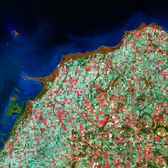
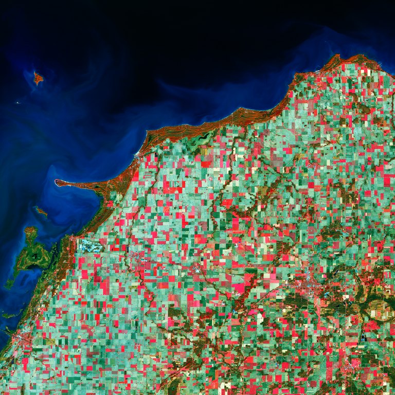
English: The Copernicus Sentinel-2A satellite takes us over Lake Huron, the second largest of the five Great Lakes of North America. Bound on the north and east by the Canadian province of Ontario and on the south and west by the state of Michigan in the U.S., Lake Huron was the first of the Great Lakes to be seen by Europeans in 1615.
This image highlights the dominance of agricultural production in the region where conditions are ideal for cultivating corn, soybeans and hay. The coloured blocks in the image show a grid-like structure for growing crops, typical of American agricultural practice. This image also shows signs of sediments and algae bloom along the coast, one of the consequences of intensive agricultural activity in a region that responds to the ongoing demand for produce. Lake Huron is around 330 km long from northwest to southeast. Covering an area of over 244 000 sq km and containing around 22 600 cubic km of water, together the Great Lakes form the largest connected area of fresh, surface water on Earth. The only places that hold more fresh water are the polar ice caps. Many islands lie in the northeastern part of the lake, with Heisterman Island, North Island and Middle Grounds Island, home to Wild Fowl Bay State Park, shown on the bottom left of the image. This image, which was captured on 1 December 2017, is also featured on theEarth from Space video programme. |
| Date | |
| Source | http://www.esa.int/spaceinimages/Images/2018/06/Lake_Huron |
| Author | European Space Agency |
| Permission (Reusing this file) |
contains modified Copernicus Sentinel data (2017), processed by ESA,CC BY-SA 3.0 IGO |
| Other versions |
|
| Title | Lake Huron |
| System | Copernicus |
| Set | Earth observation image of the week |
| Mission | Sentinel-2 |
| Activity | Observing the Earth |

Licensing
editThis media was created by the European Space Agency (ESA).
Where expressly so stated, images or videos are covered by the Creative Commons Attribution-ShareAlike 3.0 IGO (CC BY-SA 3.0 IGO) licence, ESA being an Intergovernmental Organisation (IGO), as defined by the CC BY-SA 3.0 IGO licence. The user is allowed under the terms and conditions of the CC BY-SA 3.0 IGO license to Reproduce, Distribute and Publicly Perform the ESA images and videos released under CC BY-SA 3.0 IGO licence and the Adaptations thereof, without further explicit permission being necessary, for as long as the user complies with the conditions and restrictions set forth in the CC BY-SA 3.0 IGO licence, these including that:
See the ESA Creative Commons copyright notice for complete information, and this article for additional details.
|
 | |
This file is licensed under the Creative Commons Attribution-ShareAlike 3.0 IGO license. Attribution: ESA, CC BY-SA IGO 3.0
| ||

|
This image contains data from a satellite in the Copernicus Programme, such as Sentinel-1, Sentinel-2 or Sentinel-3. Attribution is required when using this image.
Attribution: Contains modified Copernicus Sentinel data 2018
The use of Copernicus Sentinel Data is regulated under EU law (Commission Delegated Regulation (EU) No 1159/2013 and Regulation (EU) No 377/2014). Relevant excerpts:
Free access shall be given to GMES dedicated data [...] made available through GMES dissemination platforms [...].
Access to GMES dedicated data [...] shall be given for the purpose of the following use in so far as it is lawful:
GMES dedicated data [...] may be used worldwide without limitations in time.
GMES dedicated data and GMES service information are provided to users without any express or implied warranty, including as regards quality and suitability for any purpose. |
File history
Click on a date/time to view the file as it appeared at that time.
| Date/Time | Thumbnail | Dimensions | User | Comment | |
|---|---|---|---|---|---|
| current | 15:56, 22 June 2018 |  | 5,014 × 5,014 (162.9 MB) | Fæ (talk | contribs) | European Space Agency, Id 395647, http://www.esa.int/spaceinimages/Images/2018/06/Lake_Huron, User:Fæ/Project_list/ESA |
You cannot overwrite this file.
File usage on Commons
The following page uses this file: