File:Leafield, Palaeolithic handaxe (FindID 240330).jpg
Size of this preview: 800 × 521 pixels. Other resolutions: 320 × 208 pixels | 640 × 417 pixels | 926 × 603 pixels.
Original file (926 × 603 pixels, file size: 361 KB, MIME type: image/jpeg)
Captions
Captions
Add a one-line explanation of what this file represents
Summary
edit.jpg&action=edit§ion=1)
| Leafield: Palaeolithic handaxe | |||
|---|---|---|---|
| Photographer |
, Anni Byard, 2008-12-18 15:15:09 |
||
| Title |
Leafield: Palaeolithic handaxe |
||
| Description |
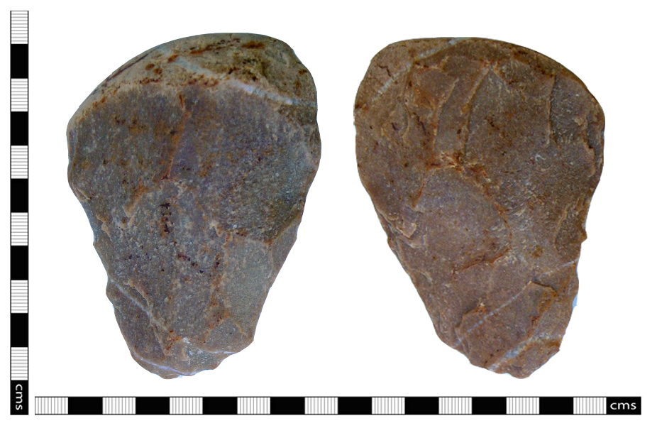
English: A Lower Palaeolothic handaxe made from a red-orange quartzite pebble with some retention of the outer cortex at the proximal end. Large bifacial flake removals evident, with smaller flaked removals at the distal end, but no further retouching is evident. The handaxe is 99.54mm in length, 70.56mm in width and 30.45mm thick. It weighs 262.8 gms and dates to the Lower Palaeolithic period, between 500,000 - 180,000 BC. Previously, no Lower Palaeolithic finds have been recorded in Leafield Parish - most sites of this period are located on or close to waterways - Leafield village is between the River Evenlode to the north and the River Windrush to the south. Although the course of these rivers have undoubtably changed in last few hundred-thousand years, the chance find of this handaxe is probably more likely to represent a casual loss rather than being an indication of a site. |
||
| Depicted place | (County of findspot) Oxfordshire | ||
| Date | between 500000 BC and 180000 BC | ||
| Accession number |
FindID: 240330 Old ref: BERK-7F2EB6 Filename: babingtonsmith axe.jpg |
||
| Credit line |
|
||
| Source |
https://finds.org.uk/database/ajax/download/id/197315 Catalog: https://finds.org.uk/database/images/image/id/197315/recordtype/artefacts archive copy at the Wayback Machine Artefact: https://finds.org.uk/database/artefacts/record/id/240330 |
||
| Permission (Reusing this file) |
Attribution-ShareAlike License | ||
| Object location | | View this and other nearby images on: OpenStreetMap |
|---|
.jpg¶ms=051.835000_N_-001.548880_E_globe:Earth_class:object_type:object__&language=en)
Licensing
edit.jpg&action=edit§ion=2)
This file is licensed under the Creative Commons Attribution-Share Alike 2.0 Generic license.
Attribution: The Portable Antiquities Scheme/ The Trustees of the British Museum
- You are free:
- to share – to copy, distribute and transmit the work
- to remix – to adapt the work
- Under the following conditions:
- attribution – You must give appropriate credit, provide a link to the license, and indicate if changes were made. You may do so in any reasonable manner, but not in any way that suggests the licensor endorses you or your use.
- share alike – If you remix, transform, or build upon the material, you must distribute your contributions under the same or compatible license as the original.
File history
Click on a date/time to view the file as it appeared at that time.
| Date/Time | Thumbnail | Dimensions | User | Comment | |
|---|---|---|---|---|---|
| current | 21:15, 31 January 2017 | | 926 × 603 (361 KB) | Fæ (talk | contribs) | Portable Antiquities Scheme, BERK, FindID: 240330, palaeolithic, page 424, batch Oxfordshire count 2492 |
You cannot overwrite this file.
File usage on Commons
The following page uses this file:
.jpg)
.jpg&oldid=728932839)